OUR VISIT TO THANJAVUR, 20TH AND 21ST NOV, 2009
CHOLA DYNASTY
The Chola dynasty ruled most of South India,Sri Lanka and parts of South East Asia from 200 BC to 1280 AD except for a period of 200 years during which they were subservient to the Pandyas and Pallavas. This is one of the longest reigns by one dynasty.
Their reign can be divided into three periods.
THE EARLY CHOLAS: FROM 200 BC TO 800 AD.
Mention of the Chola Kingdom has been made in Ashoka’s pillars of 273 BC. Mention is also found in SANGAM Literature of 150 BC, in writings by geographer Ptolemy, in the Periplus of the Erythraean Sea (Periplus Maris Erythraei) by an anonymous Alexandrian merchant of 81-90BC.
Their capitals were Urayur(now part of Tiruchirapally) and Kaveripattinam.
While the Sangam literature records the names of a number of Chola kings of this period,the most famous among these were Karikala Chola, Nedunkilli and Perunarkilli.
Mythology says that during the reign of one King Kantaman, Kaveri was brought to the earth by sage Agastya.
It is also recorded that one of the kings, Elara invaded Sri Lanka.
THE MEDIEVAL CHOLAS: FROM 800 AD TO 1070 AD:
Before the advent of medieval Cholas, they were overcome by Pandyas and Pallavas and were compelled to seek refuge under them. They continued to have their capital at Urayur and ruled a small area, till Vijayalaya rose to power in 848 AD. Taking advantage of conflicts between the Pallavas and Pandyas,he captured Thanjavur and eventually established the imperial line of the medieval Cholas. There is an abundance of materials from diverse sources about Vijayalaya and the later Chola kings. A large number of stone inscriptions by the Cholas themselves and by their rival kings, Pandyas and Chalukyas, and copper-plate grants, have been instrumental in constructing the history of Cholas of that period.
Under Rajaraja Chola I and his son Rajendra Chola I, the dynasty became a military, economic and cultural power in South Asia and South-east Asia.At its peak, the Chola Empire stretched from the island of Sri Lanka in the south to the Godavari-Krishna basin in the north, up to the Konkan coast in Bhatkal, the entire Malabar Coast in addition to Lakshadweep, Maldives and vast areas of Chera country. The kingdoms of Deccan and the eastern coast were subordinates, feudatories of the Cholas.Other kingdoms like the Chalukyas between 1000-1075 AD paid tribute to the Cholas. Rajendra Chola I completed the conquest of the island of Sri Lanka and captured the Sinhala king Mahinda V prisoner, in addition to his conquests of Rattapadi (territories of the Rashtrakutas, Chalukya country, Talakkad, Kolar (where the Kolaramma temple still has his portrait statue) in Kannada country. In addition Rajendra's territories included the area falling on the Ganga-Hooghly-Damodar basin, large parts of Burma, Thailand, Indo-China, Laos, Kambodia, the Malay Peninsula and Indonesia. The kingdoms along the east coast of India up to the river Ganges acknowledged Chola suzerainty. Chola navies invaded and conquered Srivijaya in the Malayan archipelago.The wars against the Chalukyas were mainly fought in Chalukya territories in Telugu country like Vengi, Kakinada or Anantapur or Gutti.
Marital and political alliances between the Eastern Chalukya kings based around
Vengi located on the south banks of the River Godavari began during the reign of
Rajaraja following his invasion of Vengi. Rajaraja Chola's daughter married the
Chalukyan Prince Vimaladitya. Rajendra Chola's daughter was married to
Eastern Chalukya Prince Rajaraja Narendra( the mentor of Nannaya, author
Of Mahabharata in Telugu).
Under the Cholas, the Tamil country reached new heights of excellence in art, religion and literature. Monumental architecture in the form of majestic temples and sculpture in stone and bronze reached a finesse never before achieved in India. With heavily ornamented pillars accurate in detail and richly sculpted walls, the temples are classic examples of Chola art and architecture.
Temple building received great impetus from the conquests and the genius of Rajaraja Chola and his son Rajendra Chola I.The maturity and grandeur to which the Chola architecture had evolved found expression in the two temples of Thanjavur and Gangaikondacholapuram. The magnificent Brihadisvara temple in Thanjavur, completed around 1009 AD, is a fitting memorial to the material achievements of the time of Rajaraja. The largest and tallest of all Indian temples of its time, it is at the apex of South Indian architecture.
This temple along with the temple of Gangaikondacholisvaram at Gangaikondacholapuram and the Airavatesvara Temple at Darasuram were declared as World Heritage Sites by the UNESCO, and are referred to as the Great living Chola temples.
Another famous form of art was the bronze figurines that were crafted during this time. The craftsmen used to beautifully decorate the statues with garlands and jewelry while carving the statue itself. Famous examples of bronze statues are the Nataraja and Lord Shiva as Ardhanarishwara.
The Chola conquest of Kadaram (Kedah) and Srivijaya, and their continued commercial contacts with the Chinese Empire, enabled them to influence the local cultures. Many of the surviving examples of the Hindu cultural influence found today throughout the Southeast Asia owe much to the legacy of the Cholas.
The Tang dynasty of China, the Srivijaya empire in the Malayan archipelago under the Sailendras, and the Abbasid Kalifat at Baghdad were the main trading partners.
In general, Cholas were adherents of Saivite Hinduism but were favourably disposed towards Vaishnavism. Throughout their history, they were not swayed by the rise of Buddhism and Jainism.However during the rule of the later Cholas there seems to have been some antagonism towards Vaishnavism, specially against Sri Ramanuja.The age of the Imperial Cholas (850–1200) was the golden age of Tamil culture, marked by the importance of literature.
Kamban flourished during the reign of Kulothunga Chola III. His Ramavatharam (also referred to as Kambaramayanam) is a great epic in Tamil literature.
Jayamkondar’s masterpiece Kalingattuparani is an example of narrative poetry that draws a clear boundary between history and fictitious conventions.
The famous Tamil poet Ottakuttan was a contemporary of Kulothunga Chola I and served at the courts of three of Kulothunga's successors.Ottakuttan wrote Kulothunga Cholan Ula, a poem extolling the virtues of the Chola king.
Jain and Buddhist authors flourished as well, although in fewer numbers than in previous centuries.Jivaka-chintamani by Tirutakkatevar and Sulamani by Tolamoli are among notable by non-Hindu authors.
LATER CHOLAS: 1070 TO 1279 AD.
In 1070 AD, Kulothunga Chola I, the son of Rajaraja Narendra(Chalukya Chola), ascended the Chola throne starting the Later Chola dynasty. The rule of the later Cholas was not as strong as those of the emperors up to Rajendra Chola II. The decline of the Chola power started beginning 1215 AD. The Cholas lost control of the island of Lanka and were driven out by the revival of Sinhala power. Around 1118 AD, they lost control of Vengi to the Western Chalukyas and Gangavadi (Southern Mysore districts) to the Hoysalas. The Hoysalas were routed from Kannanur Kuppam around 1279AD by Kulasekhara Pandiyan and in the same war the last Chola emperor Rajendra III was routed and the Chola Empire ceased to exist thereafter.
BRIHADEESWARA TEMPLE, THANJAVUR
The temple gateway
The temple complex sits on the banks of a river that was channeled to make a moat around the complex's outer walls, the walls being built like a fortress. There is a small bridge across the moat giving access to the temple gateway. The complex is made up of many structures that are aligned axially. The complex can be entered either through a five-story gopuram or directly to the huge main quadrangle of about 152.40x76.20 m, through a smaller free-standing gopuram.
The Temple
This temple is one of India's most prized architectural sites. The temple stands amidst fortified walls. The 'Vimana' - or the temple tower - is 66 m high and is among the tallest of its kind in the world. This is referred to as Dakshina Meru. It is a tower of fourteen storeys, finely decorated with pilasters, niches and images of gods of the Hindu pantheon. The plinth of the Central Shrine is 45.72 square m., while the shrine proper is 30.48 square m.
The Kalash or 'Shikhara' (apex or the bulbous structure on the top) of the temple, an octogonal structure, is about 4 m high and is of monolithic granite weighing 81.25tons. It is believed that this block was carried up a specially built ramp from Sarapallam, a site 6 kilometers away from the temple. It is said that the shadow of the temple tower does not fall on the floor at any circumstances by sun light.
The Shivalingam - Peruvudaiyar, Rajarajeswaramudaiyar - is a huge one about 4 m high, set in a two storeyed sanctum.The walls surrounding the sanctum delight visitors as a storehouse of murals and sculpture.
A 107 paragraph long inscription on the walls of the Vimanam records the contributions of Raja Raja Chola and his sister Kundavai to the Thanjavur temple.
The temple is an example of the architectural conception of the pure form of the Dravida type of temple architecture and representative of the Chola Empire ideology and the Tamil civilisation in Southern India. The temples testify to the brilliant achievements of the Cholas in architecture, sculpture, painting and bronze casting. The entire temple structure is made out of hard granite stones, a material sparsely available currently in Thanjavur area where the temple is located.
There is a big idol of Nandi (sacred bull),facing the Sanctum Sanctorum, dating back to the Nayak rule, carved out of a single rock, at the entrance measuring about 5 m long and 4 m high, and weighs about 25 tonnes.
THE PALACE
The palace is located inside the fort and consists of large buildings constructed during the Nayak and Maratha periods. The world famous bronze musuem, Maharaja Sarfoji’s Saraswathy Mahal library, Sangeetha mahal, Art Gallery, Lakshmi Vilas Durbar hall, the Royal museum(personal collections by the Maratha kings),Raja Sarfoji Memorial hall and museum are all part of the palace complex. The whole complex is in extremely poor condition. Grass has grown everywhere. There are cobwebs all over. Structure is dilapidating.
The Saraswathy Mahal Library was a great let down. The palm leaf manuscripts are kept in glass cases, which are poorly ventilated and lit. It is supposed to have about 30,000 manuscripts and 6500 printed books. The place is not even air conditioned.
The Lakshmi Vilas durbar Hall has a single slab of granite measuring 18 ft X16 ft X 2.5 ft carved all round used as a throne by Nayak kings. It now has an intricately carved marble statue of Sarfoji in Royal attire made in England in 1807 AD. In the couple of hours we were in the palace we did not notice even one other visitor. The entry charges are Re1 or Rs.2. Dirty slips of receipts are given. The whole maintenance is dependant on Government grants. I really do not know whether any grants are being received and how they are being spent. Very soon the buildings will crumble to dust. The whole picture is very depressing and is unlikely to attract any visitors. I learnt that they are another 15/16 rooms which were vacated by the descendants of the Marathas available with the government, which are locked up. The descendants have shifted to modern houses outside the palace.
I have collected the information about the temple from Saraswathy Mahal Library, local folk lore and some web sites.
Sunday, December 6, 2009
Saturday, October 17, 2009
HOT AIR BALLOON FLIGHT
HOT AIR BALLOON FLIGHT
One fine morning in June 2003, while we were with my son’s family in Ottawa, Canada, he took us to the office of Sky View. From there their cheerful hostess took us to the place from where the hot air balloons are launched.
We saw three huge balloons laid down on the ground. We were met by the operator who explained about the balloon and the flight.
The Balloon consists basically of the envelope (the balloon made of tough nylon), the skirt which is the bottom part of the envelope and which is made of fire resistant material, the burners and the wicker basket in which the passengers are carried. The basket, some times called the gondala also has a chamber in which cylinders of Propane gas are kept.
Most hot air balloons use a wicker basket for the passenger compartment. Wicker works very well because it is sturdy, flexible and relatively lightweight. The flexibility helps with balloon landings. In a basket made of more rigid material, passengers would feel the brunt of the impact force while landing. Wicker material flexes a little, absorbing some of the energy.
The balloon is about 70 ft high.
The propane is stored in compressed liquid form, in lightweight cylinders positioned in the balloon basket. The propane changes from a liquid to a gas as it comes out of cylinders, before it is ignited. This gas makes for a more powerful flame and more efficient fuel consumption. The lighter looks like a flame thrower. A huge fan throws air into the balloon and as it gets into the balloon it is heated by the flame, the balloon starts swelling majestically and becomes upright.
Generally since the basket is quite high, some passengers get into it in the lying down position and start standing as the balloon becomes upright. The crew hold on to the basket till the balloon is fully inflated.
We were lifted gently, watching the earth fall away below us. Soon, we were flying over the town, roads, railways and green plains at a height of about 2500 ft. We dipped down to kiss the waters of a limpid lake, then floated up again. Most of us had never seen the world from this perspective. There’s no rush, no urgency, no whirring of engines. It’s peaceful, serene and incredibly beautiful. There’s no feeling quite like it, nothing on earth that can match the magic of floating on air, the sense of being at one with the sky and looking down at a world that is looking up at you!
Piloting a balloon takes skill, but the controls are actually very simple. To lift the balloon, the pilot moves a control that opens up the propane valve. This lever works just like the knobs on a gas grill or stove: As you turn it, the flow of gas increases, so the flame grows in size. The pilot can increase the vertical speed by blasting a larger flame to heat the air more rapidly.
Before we realized it the one hour of flight was to come to an end and the pilot started looking for landing grounds. It is a remarkably serene, peaceful experience. Since the balloon moves with the wind, you don't feel any breeze at all. Without the rushing winds you normally associate with high altitudes, the experience of flying seems very safe and calming -- you simply lift off the ground and move with the air in the atmosphere.
When the pilot was ready to land, he discussed possible landing sites with the ground crew (via an onboard radio). They need to find a wide open space, where there are no power lines and plenty of room to lay out the balloon. As soon as the balloon is in the air, the pilot was constantly looking for suitable landing sites, in case there is an emergency.
We were warned that the balloon landing could be a little rough, but the pilot bumped along the ground to stop the balloon gradually, minimizing the impact. The basket remained vertical. The ground crew had made it to the landing site and held the basket down once it landed. The second balloon behind us had a rough landing. The crew had to pull it along the ground to a better spot and in the process the basket fell on its side giving a series of jolts to the passengers.
The hostess was there to receive us with a bottle of champagne and a Certificate of Hot air Balloon flying.
All in all we had a soaring experience.
FOR THOSE INTERESTED IN TECHNICAL POINTS:
Hot air balloons are based on a very basic scientific principle: warmer air rises in cooler air. Essentially, hot air is lighter than cool air, because it has less mass per unit of volume. A cubic foot of air weighs roughly 28 grams (about an ounce). If you heat that air by 100 degrees F, it weighs about 7 grams less. Therefore, each cubic foot of air contained in a hot air balloon can lift about 7 grams. That's not much, and this is why hot air balloons are so huge -- to lift 1,000 pounds, you need about 65,000 cubic feet of hot air.
Essentially, these are the only controls -- heat to make the balloon rise and venting to make it sink. This raises an interesting question: If pilots can only move hot air balloons up and down, how do they get the balloon from place to place? As it turns out, pilots can maneuver horizontally by changing their vertical position, because wind blows in different directions at different altitudes. To move in a particular direction, a pilot ascends or descends to the appropriate level, and rides with the wind. Since wind speed generally increases as you get higher in the atmosphere, pilots can also control horizontal speed by changing altitude.
The hot air won't escape from the skirt at the bottom of the envelope because buoyancy keeps it moving up. If the pilot continually fires the fuel jets, the balloon will continue to rise. There is an upper altitude limit, however, since eventually the air becomes so thin that the buoyant force is too weak to lift the balloon. The buoyant force is equal to the weight of air displaced by the balloon, so a larger balloon envelope will generally have a higher upper altitude limit than a smaller balloon.
Hot air balloons also have a cord to open the parachute valve at the top of the envelope. When the pilot pulls the attached cord, some hot air can escape from the envelope, decreasing the inner air temperature. This causes the balloon to slow its ascent. If the pilot keeps the valve open long enough, the balloon will sink.
Tuesday, September 15, 2009
UTTARANCHAL
OUR TRIP TO UTTARANCHAL
17th September 2008 to 26th September 2008.
Mumbai-NewDelhi-Haridwar-Rishikesh -Dev Prayag-Rudra Prayag- Joshi Math-Badrinath-Maana
DAY 1- 17th September, 2008:
We (a group of three couples) travelled by the Rajdhani Express from Mumbai Central on 17th September, 2008 around 5 pm and reached Nizamuddin station of New Delhi at 10am next day.
DAY 2- 18th September:
We left Delhi immediately in a tempo traveler through heavy morning rush hour traffic and reached Haridwar around 6pm.After a quick freshening up, we left for Har ki pauri (known for a footprint of Vishnu on a stone in a wall )and reached just in time to witness the evening aarti. While the aarti is in progress in the Ganga temple large number of people take a dip in the Ganga, perform pooja .Offerings of lamps and flowers are made to the river immediately following this ceremony and it is a moving sight to watch hundreds of miniature lamps float along the river In the darkness all round. After the aarti, we had darshan of all the temples in the area. The main one is for Ganga. This is supposed to be the place where Ganga landed after the penance of Bhagiratha. In fact here in Haridwar, Ganga reaches the plains. The other temples are of Anjaneya, Kalbhairav, and replicas of Badrinath and Kedarnath.
The other important temple is the Manasadevi temple situated on top of a small hill.
Haridwar is also the site of celebration of the Kumbha Mela, once in twelve years, when Jupiter transits to the zodiac sign of Aquarius.
DAY 3- 19th September:
We left the hotel very early as we had a long drive and reached Joshi math around 5pm. It is about 270 kms, and at an altitude of 1650 M. On the way we crossed Rishikesh, Dev Prayag and Rudra Prayag.
DAY 4- 20th September:
Joshi Math is one of the four great 'maths' established by the Adi Guru Shri Shankaracharya in the 8th century AD.
At Joshi math we visited the Narasimha temple, which is about 1200 years old. Dedicated to Vishnu, the presiding deity of the temple is Narsimha, the half-man, half-lion and fourth incarnation of Vishnu .This is the place where the Badrinath idol is brought and kept during winter months. The temple also had idols of Adi Sankar, Siva and Durga. There is also a tree under which Adi Sankara meditated for 5 years and then established the Sankar Math.
Situated some 30 yards from the Narsimha Temple, the Vasudeva Temple is one of the most famous Vishnu temples in north India. It was considered very sacred by the Tamil vaishnavite saints known as alvars . The presiding deity of the temple is Vasudeva who is identified with Vishnu. The idol is carved out of a piece of black stone measuring 6 feet in height.
From Joshi Math the vehicles wait in a convoy to go to Badrinath. Since the road is very narrow, vehicles from Joshimath are allowed 5 times a day at 6,9,11.30am& 2:30 and 4 pm. Vehicles from Badrinath come during the in between periods. We waited in the queue from 7.30 am, but at 2pm we were told that there was no chance of leaving that day due to heavy land slides on the way. We went back to the same hotel.
After a little rest we visited the Sankara math situated on top of a small hill. Both Dwaraka Mutt and Badri Mutt have the same Sankaracharya. However from Varanasi a Sanyasi is deputed to take care of the Mutt’s affairs when Sankaracharya is away at Dwarka. We met this Sanyasi who is in charge of the Mutt.
From Joshi Math there is a cable car service to Auli, one of the few places in India for skiing and other winter sports.
DAY 5- 21st September:
We left the hotel again by 6.30 am. and joined the queue at the check post. We were allowed to move around 2.30 pm after news came that the land slide has been cleared.
First comes Gobind Ghat from where a road goes to the Valley of flowers and a famous Gurudwara.
After some distance we could see the amount of land slides that had taken place and the efforts Border Road Organisation was taking to clear the mess. It was a stupendous task. In spite of all the machinery at their disposal they were able to clear a small way for one vehicle to pass. There was hill on one side about a hundred feet high from which the slide happened and on the other side a steep fall. The amount of earth to be cleared was enormous.
We reached Vishnu Prayag where a small river Dhauli Ganga joins Alakananda. A 400 MW capacity Hydro electric project is under construction here.
We then reached Pandukeshwar, where all vehicles stop. Here alternately vehicles in each direction are allowed to pass. We had to wait there for nearly 45 minutes.
We reached at Badrinath at around 5 pm. The distance travelled is hardly 45 kms. Badrinath is at an altitude of 3450M and the temperature was around 8 deg.C.
Badrinath is considered to be amongst the most pious of the eternal pilgrimage centres of Kedarnath, Badrinath, Gangotri and Yamunotri. Badrinath temple, dedicated to Lord Vishnu said to have been built by Adi Guru Shankaracharya in the early 9th century AD is located on the right bank of river Alaknanda, perched at an altitude of over 3100m in the middle of a valley full with scenic beauty.
The temple does not have an idol of Badrinath as understood commonly. Instead there is a large Saligram with features like carvings. The Saligram was recovered by Adi Sankaracharya from a hot spring near the temple called Tapt Kund. The diety is flanked by Nara, Narayana, Narada, Kuber, Garuda, Uddhava
There is a hot water spring, Tapt Kund, near the temple. It has hot water even when it is freezing cold all around. The spring is said to cure several diseases naturally by taking a dip in it. The other hot water springs in Badrinath are Narad Kund and Surya Kund.
Nar and Narayan Parvats with the Neelkanth peak (6,597m) in the back ground can be seen from the temple.
Since no vehicles could leave Badrinath for two days, lots of people were stranded. This caused a tremendous crowd at the temple. We had to push through them. Some how, we managed to have darshan and came out of the temple.
DAY 6- 22nd September:
Next morning it started drizzling a little. We went to the temple and stood in a queue. Devotees are let in groups of six and can remain inside for a few minutes. Luckily we could get in quickly and had a peaceful darshan. It started raining heavily and we all got wet. We returned to the hotel and after some time left for Maana which is about 3 kms from Badrinath.
Maana( actually Manibhadrapuri) is the last village before the border with Tibet. There is a tea stall which claims to be the last tea stall on Indian soil before the border. This is Kesava Prayag where Saraswathy and Alaknanda join. One can see the difference in colours of the waters of the two rivers. We went up a little hill where there is a huge boulder across Saraswathy, which is called Bhim pul. On the other side there is a cave from which water gushes out. This is said to be River Saraswathy.
There is a temple for Ganesha. It is said that he sat here and wrote the Mahabharat while Veda Vyasa dictated it. Further ahead is a cave called Vyasa Guha in which Ved Vyas is said to have done penance before dictating the Mahabharat. Beyond this is the Draupadi temple, which we did not visit. This is the point where Pandavas while going to the Heavens started falling off one by one.
We had another great darshan leisurely after lunch. We then got tickets for another darshan in the evening and retired to the hotel. We were back at the temple in the evening. This time they allowed about 40 people together and made us all sit just near the garbhagriha. The priests recited Vishnu Sahasranamam. We could sit there for nearly 40 minutes and had a wonderful darshan. Every one was over joyed that in a period of slightly more than a day we could have darshan four times.
DAY 7-23rd September:
First batch of vehicles are permitted to leave Badrinath at 9am. We left Badrinath in the first batch. Due to the time lost at Joshimath we cancelled our halt there and decided to go directly to Rudra Prayag. After Pandukeshwar, there was again some hold up. While we were waiting there we could here blasting of huge boulders which had blocked the road. We could see the smoke coming out of the blasts. Once the road was cleared we left the place. We had lunch at Pipal Kot and reached at Rudra Prayag around 5.30pm.
Rudraprayag is situated on the confluence of the rivers Mandakini and Alaknanda. It is home to the Rudranath Temple that is dedicated to Shiva. Near the temple is the place where Narada, reputed to be the inventor of the veena, a musical instrument, is believed to have meditated.
There is a fork in the road near Rudraprayag, one leading to Badrinath and the other to Kedarnath. Helicopter service is available during season from Patta near Rudraprayag to Kedarnath.
DAY 8 - 24th September:
To day, we reached Deo Prayag at 10.30am. This is the confluence point of Alakananda and Bhagirathi and from here the river gets the name Ganga. The bathing ghat on the other side of the river has three levels and we went to the lowest level to have a dip in the river. Water was freezing cold. Since the two rivers join here the water was rather turbulent. We were told during seasons the water raises up to the top most level. After the dip in Ganga we travelled to Rishikesh .
According to legend, sage Raibhya Rishi, undertook staunch penance at this place to please God. In answer to his meditation, God appeared here, manifested as `Rishikesh’ and the place thus came to be called after him.
We visited the Laxman Jhoola and some temples around it. The original jhoola, a suspension bridge made of ropes got destroyed in 1889 and a new one with steel ropes was constructed in 1939 by a business man from Kolkata. This has a span of 140 ft.
Rishikesh has become a center for learning and research in yoga and meditation, the renowned Indian methods for mental and physical health. The International Yoga Festival which attracts participation from all across the world is held here annually for one week in the month of February (2nd to 7th) on the banks of the serene Ganga.
We left Rishikesh for haridwar where we stayed the night.
DAY 9- 25th September:
We left Haridwar at 8 am and reached Nizamuddin at 2.30pm. and took the August Kranti Rajadhani express and reached Mumbai the next morning.
Friday, August 7, 2009
JORDAN PART II-PETRA
PETRA, JORDAN
HISTORY
Petra, located about 262 km south of Amman and 133 km north of Aqaba is considered the most famous and gorgeous site in Jordan. It is the legacy of the Nabataeans, an industrious Arab people who settled in southern Jordan more than 2000 years ago. Admired then for its refined culture, massive architecture and ingenious complex of dams and water channels, Petra is now a UNESCO WORLD HERITAGE SITE and one of THE NEW 7 WONDERS OF THE WORLD that enchants visitors from all corners of the globe.
The approach through a kilometer long, cool, and gloom chasm (or SIQ) a long narrow gorge whose steeply rising sides all but obliterate the sun, provides a dramatic contrast with the magic to come. Suddenly the gorge opens into a natural square dominated by Petra's most famous monument, AL-KHAZNEH (The Treasury), who’s intricately carved facade glows in the dazzling sun.
More facades beckon the visitor on until the ancient city gradually unfolds, one monument leading to the next for kilometer after kilometer. The sheer size of the city and the quality of beautifully carved facades is staggering and leads one to reflect on the creativity and industry of the Nabataeans who made Petra their capital.
Petra is breathtaking, and never to be forgotten. It flourished for over 400 years around the time of Rome and Christ, until it was occupied by the Roman legions of the Emperor Trajan in 106 AD.
The Petra basin boasts over 800 individual monuments, including buildings, tombs, baths, funerary halls, temples, arched gateways, and colonnaded streets, that were mostly carved from the kaleidoscopic sandstone by the technical and artistic genius of its inhabitants.
Petra sights are at their best in early morning and late afternoon, when the sun warms the multicolored stones, you can view the majesty of Petra as it was seen first when discovered in 1812 after being lost by the 16th century for almost 300 years!
THE DZIN
As one makes one's way through the gorge, on horseback, horse carriage or on foot, to the entrance of Al-Siq or narrow defile, the first monuments one sees are three massive Djin blocks. There are about 40 such monuments to be found in Petra. Their significance is as yet uncertain. They are generally thought to have been an early form of Nabataean tomb, though their proximity to running water may signify that they were related to the worship of water, bearer of fertility.
THE OBELISK TOMB AND THE BAB AL-SIQ TRICLINIUM
Opposite the Djin blocks are two monuments, the Obelisk Tomb and the Bab Al-Siq Triclinium, which stands below it. Although they are found in close proximity to one another, they appear to be unrelated, dating from various periods and standing on a slightly different axis. The Obelisk Tomb takes its name from the four Obelisks which decorate its upper storey.
The Obelisk was a common Nabataean funerary symbol and clearly demonstrates Egyptian influence. An inscription in both Greek and Nabataean to be found opposite it, refers to a family tomb built by Abdmank which may well be the Obelisk tomb itself.
The Bab Al-Siq Triclinium, constructed at a later date and more classical in style, is the first of approximately 100 similar monuments to be found throughout the site. These were rock-carved rooms with benches running around three sides of their interior, situated near tombs, so as to act as dining rooms for the funerary banquets which appear to have been an essential ritual in burying and commemorating the dead.
THE SIQ
Then we enter the Siq. Once inside, the Siq narrows to little more than five metres in width, while the walls tower up hundreds of metres on either side. There are many large tombs in the Outer Siq, some of them bearing obvious traces of earthquake damage. The Tomb of the 17 Graves clearly demonstrates how the graves were cut into the rock floor. Also noteworthy are the five small commemorative Obelisks and two Nabataean inscriptions carved onto the walls.
AL KHAZNEH ("THE TREASURY").
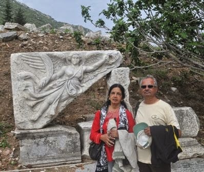
As we move along the narrow Siq, we suddenly emerge into a natural courtyard face to face with the glowing perfection of AL KHAZNEH(the Treasury). Its elaborately carved facade is alive with a cast of Nabataean deities and mythological characters - equestrian figures of the Dioscuri (Castor and Pollux) whose role in the Greek myths was to guide the souls of the dead to the Elysian Fields; dancing Amazons wielding axes; winged Victories; Medusa heads; eagles and various mythical creatures. All are funerary symbols.
At the center of the tholos - the round section between the broken pediment at the top of the facade - is the eroded relief figure of a goddess holding a cornucopia in her left arm. This has been identified as Al-Uzza, the great goddess of Petra, who was commonly assimilated with the Greek Aphrodite, goddess of love; here she includes the attributes of Tyche, the Greek goddess of fortune, and of Isis, the supreme goddess of the Egyptian pantheon who, as the wife of Osiris, also presided over the underworld and the spirits of the dead.
Though all the figures are eroded, the flowers, leaves and fruits on the friezes, pediment and capitals still look, almost as crisp as the day they were carved.
In Arabic the Treasury is called El-Khazneh, or Khaznet Far'oun, Pharaoh's Treasury, from an ancient myth that treasure had been concealed here by a powerful black magician, popularly identified with a wicked and fabulously wealthy Pharaoh, who drove prophet Moses and his followers out of Egypt and chased them here to Petra. At this point, it seems, the Pharonic treasure had become an impediment.
The Treasury's original purpose remains elusive - except that it was not a Treasury. Some scholars believe it was a royal tomb, with the king's burial place in the small chamber at the back; others, a temple, pointing to its temple-like facade and the lack of burial holes - for them the rear chamber was the sanctuary, complete with ritual ablution basin.
Yet others suggest it was a memorial mausoleum, perhaps for the cult of the deified Obodas I. The funerary symbolism of the carvings on the facade certainly points to some association with the dead. What ever it was intended to be, to day, as you enter it, you find only a 10ft.X 10 ft. chamber.
The date of the Treasury is also unclear, and has to be assessed on stylistic grounds, providing yet more theories. It is tempting to suppose that its ornate carving points to a later period, but Petra has proved a graveyard for such neat solutions.
The picturesque site is featured in various films such as: Indiana Jones and the Last Crusade, Arabian Nights, Passion in the Desert, Mortal Kombat, Annihilation, Sinbad and the Eye of the Tiger, the Sisters of Mercy, music video "Dominion", and the latest film, Transformers: Revenge of the Fallen.
The horses and the buggies take a turn from here and return to the Visitors Center.
THE ROYAL TOMBS
A stairway leads to the Royal Tombs set into the rock-face of the Jabal Al-Khubtha. These tombs, thought to be those of several Nabataean kings, are certainly amongst the most impressive of the 500 tombs to be found in Petra.
The Urn Tomb was probably constructed around 70 AD. It is preceded by a deep courtyard with colonnades on two sides. High up in the facade there are 3 niches which give on to small burial chambers. Their inaccessibility would have made them relatively safe from tomb robbers.
Inside there is a massive single chamber which may originally have served as a triclinium for funerary banquets, but which was adapted in 446 AD to serve as a Byzantine church, the vaults of which can still be seen below the tombs.
The small Silk Tomb is remarkable for the swirls of different colored rock which make up its facade. Then comes the Corinthian Tomb, which combines various elements of both the Nabataean and the classical architectural styles. Next to it is the broad, 3-storey high Palace Tomb, interesting in that its lower part was cut from the rock, while some of its upper storey was constructed with masonry when the cliff itself proved to be too low.
THE THEATER
Beyond lies the Theater. This was constructed in the early 1st century AD by Nabataeans and enlarged and improved by the Romans shortly after their annexation of the Kingdom in 106 AD. This they did by ruthlessly gouging away a street of houses or tombs in order to extend the rear of the auditorium, which could then accommodate 3000 people. This also improved the acoustics of the theater and supported a drain, which took the run-off water around the sides of the theater. The standard Roman-design theater today lies open to the Outer Siq, but would originally have been enclosed by a wall and completely cut off from the street.
OUR VISIT TO PETRA 20TH APRIL, 2008
We left the hotel in Amman around 6 am. It is necessary to reach Petra as early as possible to avoid noon sun. It took us around 3 hours to reach Petra. From the visitors center one can walk, take a horse ride or ride in a horse buggy up to The Al Khazne. All of us preferred to walk the distance of about 500 meters. Along the road we see the Dzin, Tombs and then we enter the Siq. Once inside, the Siq narrows to little more than five metres in width, while the walls tower up hundreds of metres on either side. The floor, originally paved, is now largely covered with soft sand, although evidence of Nabataean construction can still be seen in some places. On both the sides along the Siq there are carvings which are mostly worn out. The most interesting one is the human form with camel feet. Along the Siq there are covered drains. Then suddenly through a slit in the Siq you get a glimpse of the Al Khazneh. At the end of the Siq you enter a court yard. The horses and buggies come up to this point and take a turn back to the entrance. The Al Khazne is awesome. Beyond the Al Khazne are the tombs and the theater. You can read the description on each of these above. It takes nearly 4 hours to reach the center of Petra where the Byzantine church is situated. Most of us returned from that point as it was already getting too hot.
It is necessary to have lot of water and snacks ready as nothing is available once you enter Petra. Good walking shoes and a cap covering the neck are a must. As the Sun is very hot, loose full sleeved cotton clothes should be preferred. It is necessary to protect your self with Sun screen lotion. Those who are very keen to study the archeology of the place can stay over night at Petra and spend early morning and late evenings to visit the place.
I would like to acknowledge that in writing the History of Petra I have borrowed heavily from writings of some professionals, while adding substantially on my own.
HISTORY
Petra, located about 262 km south of Amman and 133 km north of Aqaba is considered the most famous and gorgeous site in Jordan. It is the legacy of the Nabataeans, an industrious Arab people who settled in southern Jordan more than 2000 years ago. Admired then for its refined culture, massive architecture and ingenious complex of dams and water channels, Petra is now a UNESCO WORLD HERITAGE SITE and one of THE NEW 7 WONDERS OF THE WORLD that enchants visitors from all corners of the globe.
The approach through a kilometer long, cool, and gloom chasm (or SIQ) a long narrow gorge whose steeply rising sides all but obliterate the sun, provides a dramatic contrast with the magic to come. Suddenly the gorge opens into a natural square dominated by Petra's most famous monument, AL-KHAZNEH (The Treasury), who’s intricately carved facade glows in the dazzling sun.
More facades beckon the visitor on until the ancient city gradually unfolds, one monument leading to the next for kilometer after kilometer. The sheer size of the city and the quality of beautifully carved facades is staggering and leads one to reflect on the creativity and industry of the Nabataeans who made Petra their capital.
Petra is breathtaking, and never to be forgotten. It flourished for over 400 years around the time of Rome and Christ, until it was occupied by the Roman legions of the Emperor Trajan in 106 AD.
The Petra basin boasts over 800 individual monuments, including buildings, tombs, baths, funerary halls, temples, arched gateways, and colonnaded streets, that were mostly carved from the kaleidoscopic sandstone by the technical and artistic genius of its inhabitants.
Petra sights are at their best in early morning and late afternoon, when the sun warms the multicolored stones, you can view the majesty of Petra as it was seen first when discovered in 1812 after being lost by the 16th century for almost 300 years!
THE DZIN
As one makes one's way through the gorge, on horseback, horse carriage or on foot, to the entrance of Al-Siq or narrow defile, the first monuments one sees are three massive Djin blocks. There are about 40 such monuments to be found in Petra. Their significance is as yet uncertain. They are generally thought to have been an early form of Nabataean tomb, though their proximity to running water may signify that they were related to the worship of water, bearer of fertility.
THE OBELISK TOMB AND THE BAB AL-SIQ TRICLINIUM
Opposite the Djin blocks are two monuments, the Obelisk Tomb and the Bab Al-Siq Triclinium, which stands below it. Although they are found in close proximity to one another, they appear to be unrelated, dating from various periods and standing on a slightly different axis. The Obelisk Tomb takes its name from the four Obelisks which decorate its upper storey.
The Obelisk was a common Nabataean funerary symbol and clearly demonstrates Egyptian influence. An inscription in both Greek and Nabataean to be found opposite it, refers to a family tomb built by Abdmank which may well be the Obelisk tomb itself.
The Bab Al-Siq Triclinium, constructed at a later date and more classical in style, is the first of approximately 100 similar monuments to be found throughout the site. These were rock-carved rooms with benches running around three sides of their interior, situated near tombs, so as to act as dining rooms for the funerary banquets which appear to have been an essential ritual in burying and commemorating the dead.
THE SIQ
Then we enter the Siq. Once inside, the Siq narrows to little more than five metres in width, while the walls tower up hundreds of metres on either side. There are many large tombs in the Outer Siq, some of them bearing obvious traces of earthquake damage. The Tomb of the 17 Graves clearly demonstrates how the graves were cut into the rock floor. Also noteworthy are the five small commemorative Obelisks and two Nabataean inscriptions carved onto the walls.
AL KHAZNEH ("THE TREASURY").
As we move along the narrow Siq, we suddenly emerge into a natural courtyard face to face with the glowing perfection of AL KHAZNEH(the Treasury). Its elaborately carved facade is alive with a cast of Nabataean deities and mythological characters - equestrian figures of the Dioscuri (Castor and Pollux) whose role in the Greek myths was to guide the souls of the dead to the Elysian Fields; dancing Amazons wielding axes; winged Victories; Medusa heads; eagles and various mythical creatures. All are funerary symbols.
At the center of the tholos - the round section between the broken pediment at the top of the facade - is the eroded relief figure of a goddess holding a cornucopia in her left arm. This has been identified as Al-Uzza, the great goddess of Petra, who was commonly assimilated with the Greek Aphrodite, goddess of love; here she includes the attributes of Tyche, the Greek goddess of fortune, and of Isis, the supreme goddess of the Egyptian pantheon who, as the wife of Osiris, also presided over the underworld and the spirits of the dead.
Though all the figures are eroded, the flowers, leaves and fruits on the friezes, pediment and capitals still look, almost as crisp as the day they were carved.
In Arabic the Treasury is called El-Khazneh, or Khaznet Far'oun, Pharaoh's Treasury, from an ancient myth that treasure had been concealed here by a powerful black magician, popularly identified with a wicked and fabulously wealthy Pharaoh, who drove prophet Moses and his followers out of Egypt and chased them here to Petra. At this point, it seems, the Pharonic treasure had become an impediment.
The Treasury's original purpose remains elusive - except that it was not a Treasury. Some scholars believe it was a royal tomb, with the king's burial place in the small chamber at the back; others, a temple, pointing to its temple-like facade and the lack of burial holes - for them the rear chamber was the sanctuary, complete with ritual ablution basin.
Yet others suggest it was a memorial mausoleum, perhaps for the cult of the deified Obodas I. The funerary symbolism of the carvings on the facade certainly points to some association with the dead. What ever it was intended to be, to day, as you enter it, you find only a 10ft.X 10 ft. chamber.
The date of the Treasury is also unclear, and has to be assessed on stylistic grounds, providing yet more theories. It is tempting to suppose that its ornate carving points to a later period, but Petra has proved a graveyard for such neat solutions.
The picturesque site is featured in various films such as: Indiana Jones and the Last Crusade, Arabian Nights, Passion in the Desert, Mortal Kombat, Annihilation, Sinbad and the Eye of the Tiger, the Sisters of Mercy, music video "Dominion", and the latest film, Transformers: Revenge of the Fallen.
The horses and the buggies take a turn from here and return to the Visitors Center.
THE ROYAL TOMBS
A stairway leads to the Royal Tombs set into the rock-face of the Jabal Al-Khubtha. These tombs, thought to be those of several Nabataean kings, are certainly amongst the most impressive of the 500 tombs to be found in Petra.
The Urn Tomb was probably constructed around 70 AD. It is preceded by a deep courtyard with colonnades on two sides. High up in the facade there are 3 niches which give on to small burial chambers. Their inaccessibility would have made them relatively safe from tomb robbers.
Inside there is a massive single chamber which may originally have served as a triclinium for funerary banquets, but which was adapted in 446 AD to serve as a Byzantine church, the vaults of which can still be seen below the tombs.
The small Silk Tomb is remarkable for the swirls of different colored rock which make up its facade. Then comes the Corinthian Tomb, which combines various elements of both the Nabataean and the classical architectural styles. Next to it is the broad, 3-storey high Palace Tomb, interesting in that its lower part was cut from the rock, while some of its upper storey was constructed with masonry when the cliff itself proved to be too low.
THE THEATER
Beyond lies the Theater. This was constructed in the early 1st century AD by Nabataeans and enlarged and improved by the Romans shortly after their annexation of the Kingdom in 106 AD. This they did by ruthlessly gouging away a street of houses or tombs in order to extend the rear of the auditorium, which could then accommodate 3000 people. This also improved the acoustics of the theater and supported a drain, which took the run-off water around the sides of the theater. The standard Roman-design theater today lies open to the Outer Siq, but would originally have been enclosed by a wall and completely cut off from the street.
OUR VISIT TO PETRA 20TH APRIL, 2008
We left the hotel in Amman around 6 am. It is necessary to reach Petra as early as possible to avoid noon sun. It took us around 3 hours to reach Petra. From the visitors center one can walk, take a horse ride or ride in a horse buggy up to The Al Khazne. All of us preferred to walk the distance of about 500 meters. Along the road we see the Dzin, Tombs and then we enter the Siq. Once inside, the Siq narrows to little more than five metres in width, while the walls tower up hundreds of metres on either side. The floor, originally paved, is now largely covered with soft sand, although evidence of Nabataean construction can still be seen in some places. On both the sides along the Siq there are carvings which are mostly worn out. The most interesting one is the human form with camel feet. Along the Siq there are covered drains. Then suddenly through a slit in the Siq you get a glimpse of the Al Khazneh. At the end of the Siq you enter a court yard. The horses and buggies come up to this point and take a turn back to the entrance. The Al Khazne is awesome. Beyond the Al Khazne are the tombs and the theater. You can read the description on each of these above. It takes nearly 4 hours to reach the center of Petra where the Byzantine church is situated. Most of us returned from that point as it was already getting too hot.
It is necessary to have lot of water and snacks ready as nothing is available once you enter Petra. Good walking shoes and a cap covering the neck are a must. As the Sun is very hot, loose full sleeved cotton clothes should be preferred. It is necessary to protect your self with Sun screen lotion. Those who are very keen to study the archeology of the place can stay over night at Petra and spend early morning and late evenings to visit the place.
I would like to acknowledge that in writing the History of Petra I have borrowed heavily from writings of some professionals, while adding substantially on my own.
Monday, August 3, 2009
JORDAN - PART I
HISTORY OF JORDAN
AMMAN
Amman has served as the modern and ancient capital of Jordan. It is one of the oldest continuously inhabited cities in the world, with a 1994 excavation uncovering homes and towers believed to have been built during the Stone Age, circa 7000 BC. There are many Biblical references to the city, which by about 1200 BC had become the Ammonite capital of Rabbath-Ammon. The Ammonites fought numerous wars with Saul, David and others.
The history of Amman between the end of its Biblical references (around 585 BC) and the time of the Ptolemies is unclear. The city was renamed Philadelphia after the Ptolemaic ruler Philadelphus in the third century BC. After coming under Seleucid and Nabatean rule, Philadelphia was taken by the Roman King Herod in 30 BC. Under Roman rule, Philadelphia was re planned and reconstructed in typically grand Roman style with a colonnaded street, baths, an amphitheater and impressive public buildings.
Amman’s modern history began in the late 19th century, when the Ottomans resettled a colony of Circassian emigrants there in 1878. Many of their descendants still reside in Amman. However, after the Great Arab Revolt secured the state of Transjordan, Emir Abdullah bin al-Hussein made Amman his capital in 1921.
Jerash
Jerash, located 48 kilometers north of Amman is considered one of the largest and most well-preserved sites of Roman architecture in the world outside Italy. To this day, its colonnaded streets, baths, theaters, plazas and arches remain in exceptional condition. Within the remaining city walls, archaeologists have found the ruins of settlements dating back to the Neolithic Age, indicating human occupation at this location for more than 6500 years.
The ancient city was buried in sand, which accounts for its remarkable preservation. It has been gradually revealed through a series of excavations which commenced in 1925, and continue to this day.
Ajloun
The road to Ajloun, located 25 kilometers west of Jerash and 73 kilometers from Amman, winds through fertile green hillsides lined with olive groves. The main attraction in Ajloun is the stronghold of Qala’at al-Rabadh, a fine example of medieval Arab/Islamic military architecture. The castle was built between1184-85 BC by the nephew of Salah Eddin al-Ayyubi (known in the West as Saladin), the great Muslim commander who waged a successful campaign to recover lands lost to the invading Crusaders.
Ajloun’s strategic position commanding the Jordan Valley, as well as the three small valleys leading to it, made it an important link in the defensive chain against the Crusaders, who spent decades unsuccessfully trying to capture the castle and nearby village. The fortress is built upon the apex of the hill above Ajloun, and offers a breathtaking view of the surrounding countryside. On a clear day you can see the Dead Sea, the Jordan Valley, the West Bank, and Lake Tiberias (the Sea of Galilee).
The King’s Highway
There are two routes connecting Amman with the south of Jordan: the Desert Highway and the King’s Highway.
The King’s Highway is the world’s oldest continuously used communication route, and is mentioned early in the Bible. In Number 20, Moses requests the king of Edom to allow his people to "travel along the King’s Highway and not turn to the right or to the left until we have passed through your territory."
Madaba
The town of Madaba, located 30 kilometers southwest of Amman, is most famous for its exquisite 6th-century mosaics. Its history dates back at least 3500 years. Madaba, which was known in the Bible as the Moabite town of Medaba, is mentioned in the Old Testament account of Moses and the Exodus (Numbers 21: 30).
Madaba’s most famous mosaic is located in the Church of St. George in the middle of town. The Mosaic Map of Palestine represents the Holy Land and its surrounding regions. Clearly visible on the map are al-Quds (Jerusalem) and the Church of the Holy Sepulchre, the Dead Sea, the Jordan River, Nablus, al-Khalil (Hebron), Ariha (Jericho), Egypt and the Nile River, Turkey and Lebanon. The mosaic was made around 560 BC, originally composed of over 2.3 million pieces, and measured a staggering 25 by 5 meters. It is estimated that 11,500 man-hours would have been required to lay the entire mosaic.
At the southern entrance to Madaba, near the King’s Highway, is the Church of the Apostles. The ruins of this Byzantine church date to 578 BC, and are currently being restored. One of Madaba’s most beautiful mosaics adorns the floor of this church. The mosaic is known as "Personification of the Sea" and it vividly depicts a woman emerging from the sea, surrounded by mythical aquatic creatures and a hodgepodge of rams, bulls, parrots and exotic vegetation. The mosaic was signed by a mosaicist named Salamanios.
Mount Nebo
Less than 10 kilometers west of Madaba is Mount Nebo, known as Pisgah in the Bible. It is where the Bible says Moses lived out his remaining days and viewed the Promised Land which he would never enter (Deuteronomy 34: 1-8). Mt. Nebo offers a fantastic view westward, with a vista that includes the Dead Sea, the West Bank, the Jordan River and, on a clear day, Bethlehem and Jerusalem.
The main mosaic, which measures three by nine meters, depicts the monastic pastime of wine-making, as well as hunters and an assortment of animals. Outside the building is an enigmatic Serpentine Cross. The figure represents the bronze serpent taken up by Moses in the desert, as well as the cross upon which Jesus was crucified. It is also said that the three wise men on their way to visit the new born JESUS took their last rest in Mount Nebo.
The Dead Sea
The Dead Sea is 75 kilometers long and from 6 to 16 kilometers wide. It is fed by the Jordan River, but it has no outlet. As its name suggests, the Dead Sea is entirely devoid of plant and animal life. This is due to an extremely high content of salt and other minerals—350 grams of salt per kilogram of water, as compared to about 40 grams in the world’s oceans. This concentration is caused by a rapid rate of evaporation. These natural elements give the waters of the Dead Sea certain curative properties, recognized since the days of Herod the Great over 2000 years ago.
The Dead Sea is also famous geographically as "the lowest point on earth," lying some 400 meters below sea level.
Visitors to the Dead Sea come away with an unforgettable swimming experience, as the high density of the water makes sinking virtually impossible. Indeed, swimming is also difficult, as one is lifted too high in the water to be able to stroke properly. More appropriate is the often-photographed pose showing a visitor reclining in the water, leisurely reading a perfectly dry newspaper.
OUR TOUR OF JORDAN 19TH AND 21ST APRIL, 2008
My self, my wife Radhika, a friend Mr. Murali Mohan and his wife Jayashree were part of the group who took this tour to Jordan organized by M/s SOTC.
We landed in Amman by Royal Jordan Airways on 19thpril 2008. We moved to the hotel. After freshening up we hired a taxi and left for JERASH. On the way we had early lunch at an Indian restaurant called Kashmere. Jerash is 48 Kms away. On arrival we purchased tickets to visit the ruins as well as to attend a show.
The show was held in a structure resembling the Roman Coliseum. Men dressed as Roman gladiators performed various marshal arts and formations( like Vyoohas mentioned in Mahabharat). The formations show how to counter an attack by foot soldiers, cavalry and archers. There was also a show with horse drawn carts similar to those shown in old movies like BENHUR.
It was a nice show with accompanying commentary explaining every move.
We then went around the ruins. It mainly consists of the Roman style coliseum, a columnade and a fort.
We then left for AJLUN, a fort about 25 Kms away. There is a long flight of steps to the top of the fort. From the top you get a good view of the Jordan valley, Dead Sea and Lake Tiberias. The fort overlooks three routes into Jordan and was effective in preventing any surprise attacks. The fort is completely in ruins. Except for the view from the top there is nothing much to see.
At Ajlun it was interesting to see, tea being kept in very large conical aluminium vessels on coal and served really hot.
We then returned to the hotel in Amman.
Next day we went in an organized tour to PETRA recognised as a UNESCO WORLD HERITAGE SITE, about which I will write separately.
On the third day, we left in the same taxi for MADABA, about 30 Kms away towards South. Inside a church in Madaba, there is a large mosaic map of Palastine (the holy land) as envisaged those days made of nearly 2.3 million coloured pieces. It is an awesome work. It is so large I could not cover it in one shot. So I had to take photographs part by part.
We then left for Mount Nebo about 10kms away. This is the place where Moses lived his last days and the three wise men rested on their way to visit the infant Jesus. It also has a large number of mosaics inside a building. Outside the building is a cross with a serpent around it. This represents the staff taken by Moses as well as the cross on which Christ was crucified. The main mosaic is too large to be photographed entirely in one shot.
From here we left for Dead Sea. A resort has been constructed on the banks of the Dead Sea, with showers, swimming pools, changing area etc. They charge a fee for entry. It is safer to use this place rather than enter the sea at unknown place. As you enter the water you can feel the buoyancy, it lifts you from the bed. It is impossible to sink or swim as you float practically at the surface of water. You can comfortably lie down flat on your back in the water and read a book or newspaper. The problem is in getting up. It is very difficult to press your feet down to the bed to lift yourself up. You need some ones help to get up. I found a solution. I floated along till I reached a very shallow point where it is relatively easier to lower the legs, and get up. Those who do not know swimming are initially scared but once they start floating they enjoy the unforgettable experience.
You will find lot of visitors applying the blackish mud all over the body and keep it for a while before washing it off. There is a belief in its curative value as it is full of many elements. One has to be careful incase there is any cut or rash on the skin, as the water will sting like acid. One has also to avoid water getting into the mouth. I tasted and found it unbearably salty. We were told that the density and brackishness are slowly increasing as the inflow of water from Jordan River has decreased substantially.
You have to scrub and wash the body really thoroughly to take off the salt. Some of us swam in the pools for a while and then left the place. We returned to Amman in time for a late lunch in Kashmere and retired for the day.
Thursday, July 30, 2009
MAHABALIPURAM / MAMALLAPURAM
Mamallapuram is located about 60 Kms.South of Chennai (Madras) on the shores of the Bay of Bengal, along the Indian eastern coast. Known for its rock carvings and monolithic sculptures it has the famous Shore Temple, the only one to have survived the ravages of nature. Also known as the Seven Pagodas (temples), six now lie submerged in the sea. Mamallapuram temples whose architecture was inspired by the Pallava art were built during the period 650 - 1100 AD. It is believed to have been named after the famous Pallava King Narasimha Verma Pallava, the first, who was also known as MAMALLA, or the great wrestler. According to some historians these were built to celebrate Narasimhavarman's victory in AD. 642 over the Chalukyan king Pulakesin II.
Mamallapuram was a sea-port during the time of Periplus (1st century AD) and Ptolemy (AD 140) and many Indian colonists sailed to South-East Asia through this port town.
Mamallapuram has been classified as an UNESCO World Heritage Site.
Mamallapuram has the following sculptures:
STHALASAYANA PERUMAL TEMPLE
This temple is of Pallava period except that the original temple was expanded in Vijayanagar times. In this temple, Vishnu is seen lying on ground instead of on Adisesha, that is how the name comes.
THE SHORE TEMPLE
A temple built along the Bay of Bengal with the entrance from the western side, away from the sea. The temple was reconstructed stone by stone from the sea after being washed away in a cyclone. There are 3 shrines in the Shore Temple. Two of them are Saiva and the third is Vaishnava, with an image of Lord Anantasayi made of a single rock. There are Vimanas over the Saiva shrines, but none over the third, it seems to have disappeared with time.
Recent excavations to the north and south of the Shore Temple have revealed rock-cut figures representing religious themes of period prior to the construction to the temple. Besides, a monolithic Bhuvaraha, a reclining image of Vishnu, a base of Durga shrine with deer and a square socket possibly to accommodate Mahastambha have also been exposed. A stepped ghat facing the sea to the south of the Shore Temple was also exposed recently.
THE ARJUNA'S PENANCE
This is one of the most famous stone carvings at Mamallapuram. It is an enormous relief made on two massive boulders. One of the biggest open-air rock canvases in the world, the Arjuna's penance is 31m long and 9m high. The surface of the rock has detailed carvings, showing the most endearing and natural renditions of animals especially the elephants and monkeys. Arjuna's Penance has over 100 figures of gods and semi divine creatures, birds and beasts, man and saint and is one of the most beautifully carved structures at Mamallapuram. The figures that are sculptured on the rock are remarkable for their vitality and spontaneity and speak volumes about the skill of the sculptors.
There is another explanation to this bass-relief.
Legend has it that King Bhagiratha had to bring down to earth the celestial Ganga to sanctify and redeem the cursed souls of his ancestors. But the river in its torrential spree would deluge the earth, and so he had to undergo a penance to propitiate Shiva who finally received the flood in his matted locks and let it flow down. This was a sight for the world's creatures to see and they gathered round. The cleft in the rock depicts the descent of Ganga, a theory supported by the ruins of a stone water tank on the hill. There is a forest with tribal people and all forms of fauna, just as they would appear in their habitat. Women clothed in an aura of amazing grace, a rich inner beauty transfiguring the plainest of them.
THE FIVE RATHAS
The five Rathas include The Yudhishtra, Bhima, Arjuna, Nakula/Sahadeva and Draupadi. The five Rathas, about 200 m south of the main hill, were fashioned out of a smaller hill sloping down from the south. From the largest part was made the biggest of the five rathas, the Yudhishtra. Then followed onwards north, in the descending order of height, Bhima, Arjuna and the Draupadi.
A little to the west of Draupadi there was a comparatively large rock and out of it the Nakula/Sahadeva Ratha was made. Immediately in front of the Draupadi again two smaller rocks were sculptured into an elephant and a lion. Behind the Draupadi and the Arjuna, which stand on a common base, there is a Nandi.
These five Rathas were all carved out of a single piece of granite in situ.
OTHER IMPORTANT STRUCTURES are the Mahishamardhani, the Adivaraha and Govardhanadhari temples
IN CONCLUSION
As mentioned at the start of this article, Mamallapuram lies approximately 60 Kms, South of Chennai. There are two excellent roads from Chennai,the East Coast Road and the Old Mahabalipuram Road. The distance can easily covered by car in about 75 minutes.
I found that generally visitors leave Chennai after breakfast, say around
9 am and reach by 10.15am. They spend the day visiting all the places and leave Mamallapuram by 5.30 pm to return to Chennai by dusk. I thought this is a little tedious as the place is very hot during the day due to rock formations.
So we decided to reach by 3pm by a private car. We had sufficient time to have darshan of Sthala Sayana Perumal.We then went around visiting Arjuna Penance, Krishna Butter ball, Govardhanagiri and Adivaraha temples. Then we spent some time on the excellent beach.
We stayed over night at Indeco Boutique Resort (also known as Sterlng Resort) which is right near the sea shore. A paved path of about 100 M connects to the beach. This resort has all cottage type accommdation and looks like a heritage structure.
There are quite a few good resorts and hotels in Mamallapuram for all budgets.
The next morning we left the resort at 6.30 am and visited the Shore Temple. We had really a leisurely look as we were the only visitors at that hour. After that we again spent some time on the beach. We then returned to the resort for breakfast and left immdiately for another round. This time we visited the Pandava Rathas and Mahishasuramardhini cave. We had another darshan of Perumal also.
All this could be done comfortably in the cool climes of evening and early morning and one could also enjoy the beach.
Another interesting factor is that there are a large number of sculptors in the place. All along the road you can see wonderful sculptures of all sizes and shapes from mytholgy, history and some of even Venus.
We found that the State Road Transport Corporation is running ordinary and airconditioned express buses to Chennai(Adyar,T.Nagar and Koyambedu) at frequent intervals. We took the airconditioned bus which left at 11.30 am. The journey was very comfortable. Surprisingly the charge was only Rs.55. per head.The bus took only 40 minutes to reach ADYAR, from where we took an auto riksha to go home.
In the photos serial no. 1 to 24 are ancient sculptures while the rest are of modern origin.
14and 15th July, 2009
Sunday, June 14, 2009
ROCK CLIMBING AND RAPPELLING AT MUMBRA. 07TH JUNE, 2009
ROCK CLIMBING
It is not quite easy to define rock climbing, but it is not difficult too. Anyone who claims to be a rock climber has his own version of the game. Rock climbing for some is to challenge their spirits and explore new heights, to give a fillip to their unbounded imaginations; for others, it is a way telling the world that he/she has finally arrived. For many of the professional rock climbers, it is not a sport. Can you call a mission to moon a sport or pastime? If not, then why should rock climbing be called a sports is the argument. For them, rock climbing is an adventure of the greatest magnitude; it is a fight against self, against the elements, and the ultimate goal is to reach the summit and return back alive.
Rock climbing is a test of strength, concentration and coordination as well as skill and technique. A climber learns from experience that the mountain must not be taken for granted.
It can be rough and antagonistic to those who venture to come to grips with it. Nevertheless, as a sport, climbing continues to offer a thrill and challenge that is compulsive.
In India, rock climbing, as most other adventure sports, is a relatively new sport. However, in a short span of time, it has become the most popular adventure sport. Because of the good distribution of great climbing rocks throughout India, coupled with the element of excitement involved, rock climbing has become the sport to participate in for the young and the old alike.
Courtesy Temple Pilots)
Today I went for a rock climbing and rappelling expedition. We were a group of 8 people led by the organisors, who were 5.
We left Dadar, Mumbai, about 7 am and reached Mumbra about 8am. From there it took us another hour to reach the foot of the rock. Mumbra, just after Thane has a temple well known to everyone in Maharashtra. The temple is situated atop a hill around
100 M high with a steep set of steps.
About half way through, one has to walk into a jungle on the right side which leads to a number of rock formations. This is where rock climbing is done. The rock we tried was about 25 M high.
The instructor explained how climbing and rappelling has to be done.After the harness and helmet are put on,the rope hanging from top of the rock is clamped to the harness near the waist. The person on top of the hill who controls the slack of the rope has to be warned that climbing is going to start.Out of the four limbs,three should always be holding on to the rock. One has to find a proper foot hold or grip for the hands. Then weight of the body should be shifted to that limb and with the help of the other three limbs the body has to be pulled upwards.While doing this further holds should be checked.After a little climbing the rope will slacken and the controller has to be told to tighten it. This is done to prevent deep fall in case one slips.The climb was rather difficult as not many holds were available for your limbs. Some how, some of us managed the climb.
RAPPELLING
Rappelling is a form of controlled descent from the top of the hill, using a rope anchored at the top. It relies on the friction between the rope and your body, or through a mechanical device (billet).Generally the rope is passed through a friction device in your harness. One hand is used to guide your descent while the other hand regulates the pace of your descent. Your body should be in an ‘L’ shape, with legs straight, feet apart planted firmly on the rock surface. Your body weight takes you down while the friction device controls the pace of the descent. You have to slowly walk backwards down the rock face, while releasing the rope with the rear grip.
After the difficult climb,rappelling was not very difficult, everyone did it with ease.
It was extremely hot and humid and every one was tired by 11am, by which time all participants had tried and some completed the climb.
Saturday, May 30, 2009
PARAGLIDING , 14TH MAY , 2009.
PARAGLIDING , 14TH MAY , 2009.
You want to fly? Why do you want to fly hundreds of meters above the ground, over looking hills, fields and rivers? It is a challenge, a dream, an intimacy with nature and the beauty of the open blue sky, the clouds, the birds and the wind blowing into your face, which is difficult to explain.
This is why some take to Para gliding.
My son Ravindra is a trained para glider. For quite some time, I have been asking him to take me for the gliding. At last we made it on Thursday the 14th May, 2009. We traveled to a place called Karla about 100 kms. from our place on the Mumbai- Pune road (just beyond Lonavala, a hill station). The para gliding club has an office cum residential accommodation there. We had lunch and waited for some time as the day was very windy for gliding. Around 3pm we left from there and traveled about 15 kms on a gravel road to reach the foothills. Since the road is bad, we traveled in a SUV. There is a plain ground at that point which is used for landing as well as for training recruits in ground handling of the glider. We climbed up from there to a hill top about 100 M high, which is reasonably plain for take off. We used local boys for carrying the equipment up and down the hill. First I wanted to try. A harness was put on me and I was clamped to the instructor who was behind me. The instructor first makes the glider float and suddenly turns and we start running for a small distance and then we take off. We went to about 350m height and flew for about half an hour. He did a few acrobatics after confirming that I am not scared or suffer from vertigo or other problems. It was a little scary, but was thrilling. We tried to land at the same point from where we took off, but because of high velocity winds and shortage of space there, we could not land. After some more flying we landed in the plain below. Over all it was a great experience. Then my grand daughter Rhea, all of 6 years age, wanted to try. The harness was put on her. Ravi checked with her whether she is comfortable. She seemed to be amused by the whole thing and said she is fine. Then they took off. We could see that she was really enjoying the flight. She was waving her hands to us from that height. We saw that the instructor was doing acrobatics. I was a little bit worried. After about half an hour flight they landed in the plain where we were waiting. We could see the thrill on her face. The instructor told us that she asked him to do the acrobatics. When he started coming down to land, it seems she told the instructor that she felt that the flight should never end. She also told him that she will come back and learn to fly solo soon. These flights normally last for 10 minutes, but because of Ravi's association with the school, both my self and Rhea flew for more than half an hour each. The training school is run by two instructors. One of the instructors competes at national level competitions.
Friday, May 8, 2009
RIDEAU CANAL AND ICE SCULPTURES, OTTAWA, CANADA
RIDEAU CANAL AND ICE SCULPTURES IN OTTAWA, CANADA
RIDEAU CANAL, about 8 kms long flows through Ottawa, Canada. This completely freezes during winter and is used by locals as a skating rink. They claim it as the longest skating rink in the world.
When the canal is frozen, shops lending skating equipment and food courts are set up at both the ends of the canal. During week ends there is so much crowd, one feels as though the whole of Ottawa is present at the canal. For those who cannot skate a push cart similar to a child’s perambulator with skis is also lent. One can comfortably sit inside this and cover with blankets. The skater holds on to grips on this and pushes the cart while skating.
During the winter festival a sculpting competition is held. A large number of sculptors from all over the world assemble here to show off their artistry. Different themes are selected by the sculptors for the sculptures. It is very interesting to see them with drawings and cutting, chiseling and polishing huge blocks of ice. They make temporary supports for propping the sculpture till it is finished.
The work is so fine, it is only a few mm in diameter to depict strings of an instrument like lute or hair of a women. The balancing of the sculpture is very vital. When a horse is shown standing on two legs, the weight of the horse has to be perfectly balanced on the legs. Sometimes when the sculpture is complete, due to improper balancing it is heart wrenching to see the whole sculpture breaking into pieces.
We visited the canal and sculpture shows in Feb, 2004. It was still freezing out side and we had to wear a lot of protective clothing. We hired a push cart in which I sat with my grand daughter Rhea, while my son Ravi skated for some time while pushing the cart. My wife Radhika and daughter in law Pritti were spectators.
Thursday, May 7, 2009
ICE HOTEL, QUEBEC, CANADA
ICE HOTEL(HOTEL DE GLACE)
DUCHESNAY QUEBEC
CANADA
ICE HOTEL is constructed every year at DUCHESNAY, which is about 20 Kms from Quebec City in Canada. This is constructed entirely of ICE. Ice blocks are specially made taking care not to have any air bubbles, since air bubbles will not allow proper cutting and shaping. The idea of the hotel originates from the INNUI IGLOOS.
The snow is sprayed on huge inverted catenary shaped steel forms and allowed to freeze. After a couple of days, the forms are removed, leaving a maze of free-standing corridors of snow. In the corridors, dividing walls are built in order to create rooms and suites. Icehotel opens in phases, the first phase opens in the beginning of December and for each week, another part of the hotel opens up for visitors and guests until the beginning of January when the entire construction is completed. Guests are allowed till mid March after which the ice starts melting. When completed, the hotel features a bar, church, main hall, reception area, a small theater and rooms and suites; and for guests to sit and sleep, blocks of sculpted ice in the form of chairs and beds are made.
The building spans an area of 6000 Sq.m and approximately 20000 MT of ice/snow is used in the construction. Just about 60 people work on the construction, cutting and laying the blocks and laying the electrical wiring. The blocks are jointed with a material called SNICE. The walls are more than 1.2 m thick on average. All of the furniture is made of ice, including the reception tables,bar table and bar stools, beds,chairs and even some drinking glasses and plates. Architecture and design vary every year.
We traveled from Ottawa to Montreal, changed trains and reached Quebec, where we stayed for the night. Quebec was earlier a French colony and joined Canada later on. So the language and culture are all French. The river Quebec was frozen and breakers were working for breaking the ice. Even in Quebec City there are a few structures made entirely of ice blocks, but you cannot go into them. In Quebec in December day light is available for only 6 to 7 hours.
We were picked up by courtesy coach next morning and we reached DOUCHESNAY around 9 am. We were wearing three layers of clothing in addition to the thermals. There was very heavy snowing, so we had to wear a wind cheater also over all these.
We went in DeceMber 2003 just after the hotel opened to guests. The hotel had 32 ordinary suites including a few theme suites, two bars, one chapel and a theater. You will be given a WHITE WEDDING CERTIFICATE if you get married again in the chapel. A white ice wall serves as screen for projection of films.
The temperatures were around minus 35 deg. C and with wind chill it was nearly minus 40 deg. C. Beds, stools are lined with reindeer furs and Arctic sleeping bags are given for sleeping. Only the bathrooms are heated, in a separate insulated structure. It is impossible to use it in the night as one has to get out of the sleeping bag, put on warm clothes to visit them. The suites do not have doors but have only deer skin curtains. Supervisors keep moving around in the night to check all guests are comfortable and no one is in trouble because of the cold. The temperature inside the suites is about minus 5 to 8 deg.C. A parallel hotel of normal construction with heating is also available to guests who are not able spend the whole night at the Ice hotel. Normally a large number of day visitors are allowed. How ever at 6pm, only those who will be staying will be permitted inside. After lunch on the first day, they hold a briefing telling us all the Dos and DON’Ts. You are advised to stop taking liquids after 5pm to avoid going to the toilet in the night. You are also taught how to get into the sleeping bags and tie them around you. We had early dinner and went inside the Ice hotel. We spent quite some time visiting all the places and also to get acclimatized. Since the out side temperature was very low, it was comfortable to be inside the hotel. We went to our suite around
9 pm, got into the sleeping bag and slept till around 4.30 am when Radhika felt a little uncomfortable. So we left the suite and went to our heated rooms. The experience was exhilarating.
There are a large number of other activities to keep you busy during the day. These include Snow mobiles, Dog sleds, archery, rock climbing (the rock is also made of ice), ice skating etc. We decided to try our hand in snow mobile and dog sled.
First we hired a snow mobile. I was to drive with Radhika on the pinion. We were given extra heavy clothing for the ride including gloves and goggles. A guide came on another mobile. One has to show an international driving licence to be allowed to drive. The snow mobile is on skis, with a 6HP engine, there is no clutch, only an accelerator and brakes.
As we started, I had to take a sharp bend and enter the track at a lower level. I could not control and hit a wall of snow. Both of us and the snowmobile were completely in snow. We were pulled out and we proceeded. I started at 60 Kms/hr and slowly accelerated to about 100 kms/hr. Problems come when you have to cross tar roads. The skis do not move on these. So you have to check for the traffic on these roads and at the same time accelerate to avoid stopping on the road. A little tricky. We drove for about an hour and stopped. The guide asked Radhika how was the drive. She told him Manohar drives faster on Mumbai roads. So on the way back I tried to go around125 kms/hr. It was absolutely fantastic. After we returned Radhika also tried her hand to drive inside the yard. We had some photos taken and left feeling high of the experience.
Next day we wanted to try the dog sled. We were taken to a kennel about 15 minutes drive away. We were explained about different breeds of dogs used on the sled, and how to drive the sled. There are three pairs of dogs for each sled. There is a bucket seat in which one person can sit. Radhika took the seat. The driver has to stand on skis projecting at the back and hold the leash and a whip. There is a bracket between the two skis which when pressed into the ground acts as a break. So I became the driver. There were three more groups with us. It was exceedingly cold that day. Our noses were becoming red and it was difficult to breathe. Our goggles were getting foggy and we could hardly see anything beyond 10 M. I was wearing three layers of gloves and found it difficult to get a grip on the leash and whip. Somehow I managed to drive for half an hour. As my finger tips stated becoming numb, I just loosened my hand within the gloves to wiggle the fingers a little, but in doing this I lost concentration and did not notice a curve. I drove the sled straight into a wall of snow. The sled over turned and both of us were in waist deep snow. We were rescued by the guide and we continued.
I found during the drive one or the other dogs used to slow down some times stop. Others have to pull them. I was told they stop very frequently to urinate and hence it is necessary to keep shouting and sounding the whip and shout MUSH. Somehow we completed the one hour drive. It was a great experience. Due to the severe cold and heavy gloves it is practically impossible to operate the camera. The trigger is so small you can hardly put your finger tip on it.Some how I managed to take a few pictures.
The biggest problem was food. We are strict vegetarians. In spite of informing them earlier, we could get only salad, potatoes, fruit juices. The salad also contains various unknown kinds of leaves. We were feeling like animals eating grass. But we enjoyed the stay and experience. Interestingly people ask for chilled beer in the restaurant. Of course we also had cold fruit juices.
The whole thing is extremely expensive. Nearly US $ 800 each for all the facilities we used for a two night stay, but I think it was once in a life time experience and worth it.
Friday, May 1, 2009
Cessna flight
On 17th April, I contacted a flying club. I told him that I would like to fly a Cessna and whether they can arrange for it.They asked me to come over on 20th April at 12 noon as a slot will be available.
I reached his office and got introduced to an instructor. He asked for my proof of identity and made me sign an indemnity bond absolving the club of any responsibility in case of accident or death during the flight.
He then took me to the ATC, Juhu, where he explained to me their working and filled in a flight report. This consisted of the name of the club, details of aircraft,expected time of departure, duration of flight,flight route and destination. It was approved and we were told to stick to an altitude of 500 to
600 ft.I found that at the ATC all timings were GMT.
He then took me to the Meteorological dept, where he collected the meteorological information expected during the flight.
We came back to the office where he explained about the flight. We were to take off at 13.00 hrs, to maintain a altitude of 500 to 600 ft and stick to a strip generally between the sea coast and the railway line. We are not permitted to go into the sea beyond a kilometer from the coast.
He then took me to the aircraft. It was Cessna 152,twin seater,single engine, four cylinders and 108HP power. He explained to me with a check list,all the instruments on the panel and the external features like the rudder, ailerons, elevators etc. We also checked the quantity of fuel in the tank.The identification of the aircraft was VT CCC, which was to be repeated every time we contact the ATC.
I was then introduced to the pilot instructor who will take me along with him in the flight.
We got into the air craft and the instructor after getting clearance from the ATC started taxi-ing towards the start of runway. While moving he explained all the features of the instrument panel again and also how to handle the stick(steering) to raise or to lower the aircraft.
At the start of the runway he asked me to raise the engine speed for take off and start accelerating slowly. The air craft started moving forward and picked up speed. He then asked me to pull the stick to raise the nose of the plane. The aircraft started raising off the run way. I took it straight for some distance till we reached an altitude of 500 ft. Then I lowered the nose to let it fly at the same height.We flew for about half an hour. I tried to keep the aircraft on course and at the specified altitude. Thee were some air pockets where I experienced some wobbling.The pilot did some minor correction when ever necessary.We were flying at around 80 knots.
On our return journey, I noticed the new VIPASSANA GLOBAL PAGODA and wanted to see it better. The instructor took over the controls and went round the structure so that I could get a good view.It is a great civil engineering structure.
Then I pointed out to him the building in which I lived. He took a little de-tour and went round the building.It was nice to see our building (approx. 300 ft high) from the air. I took some photographs both of the Pagoda and our building.
I continued to control the air craft there after till we came near the airstrip. The landing appeared difficult due to some tall palms directly in the landing path. The instructor took control and landed the craft safely.
I thanked the instructor for an excellent flight and great experience.
Wednesday, April 22, 2009
Sky Dive
SKYDIVE
MY FIRST TANDEM SKY DIVE ON 23RD March 2003
I did a tandem sky dive at a place called GANANOQUE, Ontario, Canada. This place is about an hour’s drive from Ottowa, where my son Ravindra was living.
We had an appointment at 11.00 am. We reached the place around 10.30 am. It was a desolate airport with a small hangar and two rooms. No one was in sight. Exactly at 10.45 am three people came in an SUV.
They introduced themselves as a pilot, instructor and Radio operator.
They opened the room and the hangar and I found a small rickety plane. The pilot hooked a wire rope to the nose of the plane and pulled it on to the tarmac. The trainer started giving me instructions about the plane, my harness, the height we will go and the height at which probably the parachute will be opened. He helped me put on the harness. Meanwhile the Radio operator contacted the airports in the neighbour hood to inform them about our flight. All this took hardly 10 minutes.
There was a notice board on which was written:
"HAVE YOU EVER EXPERIENCED ABSOLUTE FEAR?”
I said,”YES” as I had faced a gun of a terrorist in Assam.
He said you will feel the same again.
They took some signatures immunizing them in case of any thing unto wards happening.
We went to the plane. It was absolutely bare, no seats, no doors . I got into it and sat in VAJRASAN pose near the opening.The instructor got in behind me and sat similarly. He then hooked me onto him. The plane started going up steeply. After sometime the pilot said that we were at about 5000 ft. Then he turned back and started back towards the airstrip while still going up. At one point he made a signal that we are at 11000 ft and we should jump. We were vertically above the air strip. I put one leg out, but could not take the other leg out as I got a chill run along my spine.
The instructor shouted at me and practically pushed me out. For the first few seconds I was dazed. Then I opened my eyes to find that I was floating in air. The instructor told me to keep my hands flat out to offer maximum resistance to the up flow. I relaxed and for the next 45 seconds it was absolute ecstasy. No words can explain the feeling. I was even bold enough to ask him some questions.
Then suddenly he asked me to pull the parachute ring. When I pulled there was a jerk taking me up and another a little later which slowed down our descent. The parachute had opened, I asked him is that all?
He said we are at 4000 ft and the parachute has to be opened for safe landing. He then made me carry out some maneuvers for change of direction etc. With some help from the instructor I could land at the exact place.
I was told that while falling from 11000 ft to 4000 ft in 45 seconds, we were falling at more than 200 Kms per hour just before opening the parachute.
You cannot explain the thrill. One has to experience it. Interestingly I was told that the oldest person to sky dive was an 80 year old Canadian woman.
Who ever has done sky diving even once will agree that it is an adventure of a life time. Think how mesmerizing an experience it is when you take free fall out of a plane which is almost at 11000 ft above mean sea level. One need not be a dare devil to do it, but one will end up feeling like one once you complete the experience.
Tuesday, April 21, 2009
WHITE WATER RAFTING IN GANGES
The sport of white water rafting seems to be glamorous, but cannot be taken lightly. It will give you more than just a rush of adrenalin. You get to experience the sheer power of nature and ways to meet the challenges like a true adventurer. One need not be an ace swimmer to do rafting, as long as you are wearing a life jacket and are with an expert supervisor. River Ganges near Rishikesh is an ideal location. The rapids have been given glamorous names like Golf Course, Roller coaster etc. We went from Mumbai to Delhi by air and took a train to Haridwar. From Haridwar, Byasi is about 70 kms. We took a private bus up to Rishikesh and a Sumo from there to reach the place. The camp is on the river bank about 75 metres lower from the road. We have a steep climb down to the place. The camp consists of about thirty tents accommodating two persons each. There is a large parachute hung from a tall pole used as a dining hall. There is a separate tent for cooking. The toilets are chemical type. After using one has to throw bleaching powder in to the pit. No water is allowed to be used as this may contaminate the river. The day starts with breakfast and getting ready thereafter. The rafts are kept in a store along the road. We climb up to the road and take out the rafts. The rafts are then inflated using large compressors. These are then loaded on to trucks. We also get into the trucks. We are then driven to the staring point, where the rafts are unloaded and taken down to the water. On the first day we are given instructions for the rafting. We are all given life jackets to wear. You can see me wearing one in the photos. We are also given an oar each. The raft accommodates 8 persons beside the guide, four on each side and the guide at the back. We are shown how to use the oars as per instructions, forward, reverse and hold still. Some times only one side does the oaring while the other is asked to hold. This is generally just before entering a rapid. We had a group of employees from a company from Delhi along with us. So we had three rafts together. The first day’s ride is rather smooth, only up to 2nd grade. As you row and enter the rapids, the raft gets tossed about and to keep the balance and to prevent the raft getting flipped one has to row really hard. Water splashes all over you. It was really very cold. The experience was really frightening but after you come out the rapid really exhilarating that you have achieved something. Between rapids the river is really placid and everyone gets into the water and float. The water is near freezing point and first dip is a shock, then you get adjusted to the temperature and enjoy floating till we near another rapid. This continues 3 to 4 times. This stretch is about 15 kms and takes about 3 hours. Then we go to the bank, deflate the rafts and take the truck ride back to the camp. The second day starts at the point where we ended the first day and goes for another 15 kms. Here we face more difficult rapids. To day while floating we saw some water snakes going beside us. We were told they are not poisonous. The third day rafting starts more or less from the camp. The rapids in the next 15 kms are very difficult and nearly grade 4. Only a few people dared to take this trip. The first few rapids were manageable. In the most difficult one, the raft flipped and all were thrown into the water. Everyone went about 3 to 4 meters down into Ganges and came out somewhere about 100 meters away. There were rescue rafts and kayaks waiting to pick them up. Everyone was safe and had recovered from the shock and did not take the help of the rescue crafts. It was absolute bliss. We then moved to a point where there was a cliff on the bank. This was about 20 meters high. All got onto the cliff and jumped into the waters. You can see this in one of the photos. Generally we return around 2pm and have lunch and relax till the evening. Then some play volleyball while others gather around and gossip or read books. Some take a guide and go for trekking and bird watching. Some go for rock climbing. I took the trek one day and rock climbing on another day. The trek lasts for about 3 hrs. The view is spectacular and you see some interesting birds. The rock climbing is about 50 to 60 ft high. With great difficulty I could do it while all youngsters were encouraging me from below. One evening I tried my hand at kayaking. You can see this in two photos. I found it very difficult as I was getting unbalanced. I was tilting to the side I was putting the oar into the water. After a little effort I gave up. At dusk, a camp fire is stated which lasts till 10pm. All sit around carry on some activities like dumb charade, antakshari, mimicry, singing songs etc. I generally took part in dumb charade. Dinner is a parallel activity. Since all the others except me are in their 20s or 30s, I retire a little earlier, but they carry on. There is no electricity. The camp provides old model hurricane lanterns. Only the kitchen and the dining area have solar powered lamps. It is difficult to walk around the camp after dark with all the tent ropes stuck to pegs. I normally carry a head lamp like the one used by miners to all such camps. By the end of the day you are so tired you fall asleep in a second and wake up only with the wakeup call in the morning. The camp was organized very professionally, by a gentleman from Bengal. We learned later that he had a dive into Ganges from Lakshman Jhoola, probably a height of 30 metres. Food was excellent. The rafts, guides and everything was really nice. In the camp there is no radio, TV, news paper. Even mobile phones do not work unless you come on to the road. You are cut off from the world for the duration of the stay in the camp. You forget the world and enjoy the show. The whole experience was absolutely great. The surroundings, the river Ganges, the rafting and other activities were a great thrill. One gets a little frightened initially, but then once this is over it is absolute bliss.
Monday, April 20, 2009
LEH trip
TRIP TO LEH, LADAKH, 2ND APRIL TO 7TH APRIL, 2009
LEH the capital of Ladakh region is situated at a altitude of 3505 M and is towards the eastern part of the state of Jammu and Kashmir. One has to take an early morning flight from New Delhi which takes about an hour and fifteen minutes. While the temperature in New Delhi around 6am is about 25 deg C it is 4 to 5 degrees C at Leh. So, one has to go prepared to face the low temperature.
Secondly due to the altitude the air is this and requires acclimatization. Travel agents suggest a day of complete rest to get adjusted to the altitude and cold. Otherwise headaches and nausea are common.
King Sengge Namgyal who ruled Ladakh during 17th century and during whose rule Ladakh was at its greatest shifted his court from Shey to Leh.
We stayed at Holiday Ladakh a medium sized hotel which was very comfortable. We were the first visitors of the season when we landed there on 2nd April. The cold and snow were there still while there were no holiday crowds. With our back ground of active life we ignored the advice of others and went for a walk around the town of LEH for a period of 2hrs and 30 mts. We returned tired and with our heads heavy.
The next two days we visited Shey Palace which was the summer palace and monastry of the Royal family in 15th century. We also went to THIKSEY Gompa which is modeled on the Potala palace of Lhasa and then the Hemis Monastry which is the largest and richest in Ladakh. The ALCHI monastry is famous for its 1000 years old great paintings which are inside a dark room and can be seen only with torch lights. Likr Monastry has a great statue of Maitreya Buddha and a huge number of Tankas.( Brass cylinders which have to be rotated clockwise for self purification).
On the way we saw the confluence of two great rivers Sindhu(Indus) and Zanskar. White water rafting in Zanskar is supposed to be the ultimate aim of all rafters in India. Unfortunately, when we visited the river still frozen. We went to another place along the Sindhu where ghats were constructed for bathers during holy days. The water was at freezing temperature, so just sprinkled some water on our heads and left the place.
Just near LEH , there is a palace and a meeting ground where Dalai Lama would stay and deliver sermons during his visits to LEH.
About 25 kms from Leh is what is called the MAGNETIC HILL. On the road a box is marked. If you stop the vehicle in the box and leave it in neutral it will move forward on its own for about 20 M. I wanted to check what happens on the return journey. The vehicle moved up hill the same distance. It is just unbelievable. No one knows why it happens. I do not know whether any scientific study has been undertaken on this. I will have to search the web.
While these visits give you an insight into the Buddhist culture, paintings and life
The most awaited trips were to Khardungla(pass) and lake Pangong.
Khardungla is the heighest motorable road pass in the world at an altitude of 5602 M(18380ft). One can get an exellent view of the Karakoram and Zanskar ranges from here. This is 40 kms from LEH and we expected to reach in 2hrs driving time. Unfortunately there was heavy snowing along the way. We were in two cars ,in one my self and my wife Radhika and in another a young doctor couple from Hubli, Karnataka..We could hardly see the road. We reached a point about 8 kms from Khardungla when those coming from the pass asked us not to proceed further due to heavy snow. We could see snow to a height of 2 m on either side of the road. All mountains were covered with snow and it was great sight. We tried to go a little further and reached an altitude of 4570 M(15500 ft), beyond which it was impossible. We found a little wider stretch there. If we had gone further, we would not have been able to find a stretch to reverse the vehicles if we decide to return. So we got down started playing in the snow. Temperature was around minus 15 deg .C. We mad a stupid looking snow man, threw snow balls at each other for some time and turned back. My finger tips became numb when I was making the snow man even when I was wearing three layers of gloves. I could hardly operate the camera trigger.So the trip ended without us reaching the highest point.
We found herds of YAKS( a kind of cattle) and PASHMINA sheep along the way. The wool from these sheep is used for making Pashmina shawls which cost more than Rs30000 each.
By the way, I have a watch showing temperature, altitude, whether conditions and compass in addition to time. This I have been carrying for my treks in Himalayas earlier.
The next day we planned a trip to PANGONG lake, which is about 150 kms away and a drive of about four and half hours. We left at 6.30 am to avoid the risk of driving late into night in case anything happens. We drove for 80 kms to reach CHANGLA (pass) with an altitude of 5300M (17500ft). This is the third highest pass in the world.
There was snow all round. When we got down from the vehicles to have a cup of tea in a military canteen, we could feel the biting cold in spite of wearing four layers of clothing including thermal wear. Temperature was around minus 20 deg.C .The air was very thin. The ladies started feeling heavy in their heads and nausea. To avoid any one falling sick, we left the place immediately as the drive from there was a descent to 4300M (14000ft) to reach the lake. Through out the drive we found heavy snow all round and slippery roads. However we reached the lake after about 2 hours drive. It was a magnificent view. The lake stretches 140 kms in length and 4 to 10 kms wide. This is the largest lake in the Himalayas.On the other side is TIBET. The lake was completely frozen. It was a sheet of ice and all around were snow peaks. It was a dazzling sight. While every one was enjoying the location and taking photos, we found that suddenly the weather changed. It started becoming foggy. We left the place immediately and drove for about one and half hour. There we found that a military vehicle trying to pass a stationary truck had got onto the berm and standing tilted dangerously towards the gorge. An army recovery vehicle in trying to rescue pushed it further towards the danger side. The three vehicles had blocked our path. The situation appeared hopeless. We cannot proceed further until the vehicles were moved. It was snowing heavily and I did not want to get stuck there. So after lot of examination of the situation, we decided to cut the snow on the hill side to a depth of 1 M width of 2 M and a length of 5 to 6 M to allow our vehicles to pass. We had only one spade. We alternated on the task and completed it in about one and half hour. We were completely exhausted and numb with cold. Some how the drivers veered around the stranded vehicles and we managed to move on. The snow was quite heavy and soft, the vehicles were slipping even after putting on the chains. So the drivers drove cautiously and slowly. Ours was the lead vehicle. We got stuck at two more places when the wheels got bogged down in soft snow. We had to rock the vehicle and some how take it out. The drivers did not like me doing the hard work as they were afraid I will fall sick, due to lack of oxygen and cold. So I had to take the wheel at these points, instead of pushing the vehicle.
After another half an hour we saw a bull dozer of the Border Road Organisation, coming towards us from Changla. They knew there was heavy snowing and had come to clear the roads. The dozer passed us without any problem. But within a few minutes after that our vehicle front right wheel got stuck in a deep rut and could not be taken out with all our efforts. We gave up. It was around 6pm. There was panic. If we do not get out we are likely to be blanketed by snow in the night and there will be no rescue. We all started talking agitatedly on our next course of action. We did not know how far we were from Changla, where we will get some shelter and food. There was desperation. Suddenly one of us noticed that the dozer was still visible when it was going around the corners. We started shouting and waving. Luckily for us the dozer driver noticed us. He was probably 300 to 400 M away. He could not turn the vehicle due to lack of space. He brought the vehicle in reverse all the way. He was shocked to see our condition. He put a tow chain to our vehicle and pulled it out of the rut. There were huge shouts of relief. He stood there and watched till got away. Interestingly we found that Changla was hardly 200 M away. But we had lost sense of time and distance in our panic. Even otherwise no one would have made that trek of 200M in that physical and mental condition. We faced certain death in snow, if the dozer had not come back.
At Changla we had a cup of tea. The military personnel told us that the snowing was not very heavy towards Leh and asked us to leave immediately. We drove cautiously as snow was still there on the roads till we reached 3350 M(11000ft).
We reached the hotel around 9pm, after about 15 hours. All at the hotel were anxious about us and were relieved to see us safe. It was an unforgettable situation that we faced on this trip.
While all these problems were being faced no one realized that we had not eaten or drank anything for hours. We were so hungry that we gorged on the food given at the hotel and went to sleep. We had to catch a flight to Delhi at 8 am next morning.
Best time to visit.
If you are interested in looking at lot of snow, want to see frozen rivers Sindhu and Zanskar, and Pangong lake and enjoy the adventure of travelling up to the Khardungla at 18000 ft altitude in minus 20 deg. C temperatures, your best time to visit is early April. But you must be prepared with sufficient warm clothing to protect yourself (thermals, three layers over it, gloves, monkey cap, ear muffs, woolen socks and good walking shoes) also be able to survive at the rarified atmosphere. Probably it is wise to carry a portable oxygen cylinder. Most of the shops are closed during this period, that means less crowds. You can enjoy the place peacefully.
If you want only to see the snow covered peaks and the monastries and probably try the white water rafting in the Zanskar late April and early May will be ideal when the temperatures will be bearable. Spring would have set in and everything around will be green. Shops selling woolen clothes and local trinkets will also be open. Be prepared of jostling crowds.
Manohar.R 14th April, 2009
Subscribe to:
Posts (Atom)