PETRA, JORDAN
HISTORY
Petra, located about 262 km south of Amman and 133 km north of Aqaba is considered the most famous and gorgeous site in Jordan. It is the legacy of the Nabataeans, an industrious Arab people who settled in southern Jordan more than 2000 years ago. Admired then for its refined culture, massive architecture and ingenious complex of dams and water channels, Petra is now a UNESCO WORLD HERITAGE SITE and one of THE NEW 7 WONDERS OF THE WORLD that enchants visitors from all corners of the globe.
The approach through a kilometer long, cool, and gloom chasm (or SIQ) a long narrow gorge whose steeply rising sides all but obliterate the sun, provides a dramatic contrast with the magic to come. Suddenly the gorge opens into a natural square dominated by Petra's most famous monument, AL-KHAZNEH (The Treasury), who’s intricately carved facade glows in the dazzling sun.
More facades beckon the visitor on until the ancient city gradually unfolds, one monument leading to the next for kilometer after kilometer. The sheer size of the city and the quality of beautifully carved facades is staggering and leads one to reflect on the creativity and industry of the Nabataeans who made Petra their capital.
Petra is breathtaking, and never to be forgotten. It flourished for over 400 years around the time of Rome and Christ, until it was occupied by the Roman legions of the Emperor Trajan in 106 AD.
The Petra basin boasts over 800 individual monuments, including buildings, tombs, baths, funerary halls, temples, arched gateways, and colonnaded streets, that were mostly carved from the kaleidoscopic sandstone by the technical and artistic genius of its inhabitants.
Petra sights are at their best in early morning and late afternoon, when the sun warms the multicolored stones, you can view the majesty of Petra as it was seen first when discovered in 1812 after being lost by the 16th century for almost 300 years!
THE DZIN
As one makes one's way through the gorge, on horseback, horse carriage or on foot, to the entrance of Al-Siq or narrow defile, the first monuments one sees are three massive Djin blocks. There are about 40 such monuments to be found in Petra. Their significance is as yet uncertain. They are generally thought to have been an early form of Nabataean tomb, though their proximity to running water may signify that they were related to the worship of water, bearer of fertility.
THE OBELISK TOMB AND THE BAB AL-SIQ TRICLINIUM
Opposite the Djin blocks are two monuments, the Obelisk Tomb and the Bab Al-Siq Triclinium, which stands below it. Although they are found in close proximity to one another, they appear to be unrelated, dating from various periods and standing on a slightly different axis. The Obelisk Tomb takes its name from the four Obelisks which decorate its upper storey.
The Obelisk was a common Nabataean funerary symbol and clearly demonstrates Egyptian influence. An inscription in both Greek and Nabataean to be found opposite it, refers to a family tomb built by Abdmank which may well be the Obelisk tomb itself.
The Bab Al-Siq Triclinium, constructed at a later date and more classical in style, is the first of approximately 100 similar monuments to be found throughout the site. These were rock-carved rooms with benches running around three sides of their interior, situated near tombs, so as to act as dining rooms for the funerary banquets which appear to have been an essential ritual in burying and commemorating the dead.
THE SIQ
Then we enter the Siq. Once inside, the Siq narrows to little more than five metres in width, while the walls tower up hundreds of metres on either side. There are many large tombs in the Outer Siq, some of them bearing obvious traces of earthquake damage. The Tomb of the 17 Graves clearly demonstrates how the graves were cut into the rock floor. Also noteworthy are the five small commemorative Obelisks and two Nabataean inscriptions carved onto the walls.
AL KHAZNEH ("THE TREASURY").
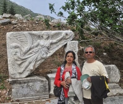
As we move along the narrow Siq, we suddenly emerge into a natural courtyard face to face with the glowing perfection of AL KHAZNEH(the Treasury). Its elaborately carved facade is alive with a cast of Nabataean deities and mythological characters - equestrian figures of the Dioscuri (Castor and Pollux) whose role in the Greek myths was to guide the souls of the dead to the Elysian Fields; dancing Amazons wielding axes; winged Victories; Medusa heads; eagles and various mythical creatures. All are funerary symbols.
At the center of the tholos - the round section between the broken pediment at the top of the facade - is the eroded relief figure of a goddess holding a cornucopia in her left arm. This has been identified as Al-Uzza, the great goddess of Petra, who was commonly assimilated with the Greek Aphrodite, goddess of love; here she includes the attributes of Tyche, the Greek goddess of fortune, and of Isis, the supreme goddess of the Egyptian pantheon who, as the wife of Osiris, also presided over the underworld and the spirits of the dead.
Though all the figures are eroded, the flowers, leaves and fruits on the friezes, pediment and capitals still look, almost as crisp as the day they were carved.
In Arabic the Treasury is called El-Khazneh, or Khaznet Far'oun, Pharaoh's Treasury, from an ancient myth that treasure had been concealed here by a powerful black magician, popularly identified with a wicked and fabulously wealthy Pharaoh, who drove prophet Moses and his followers out of Egypt and chased them here to Petra. At this point, it seems, the Pharonic treasure had become an impediment.
The Treasury's original purpose remains elusive - except that it was not a Treasury. Some scholars believe it was a royal tomb, with the king's burial place in the small chamber at the back; others, a temple, pointing to its temple-like facade and the lack of burial holes - for them the rear chamber was the sanctuary, complete with ritual ablution basin.
Yet others suggest it was a memorial mausoleum, perhaps for the cult of the deified Obodas I. The funerary symbolism of the carvings on the facade certainly points to some association with the dead. What ever it was intended to be, to day, as you enter it, you find only a 10ft.X 10 ft. chamber.
The date of the Treasury is also unclear, and has to be assessed on stylistic grounds, providing yet more theories. It is tempting to suppose that its ornate carving points to a later period, but Petra has proved a graveyard for such neat solutions.
The picturesque site is featured in various films such as: Indiana Jones and the Last Crusade, Arabian Nights, Passion in the Desert, Mortal Kombat, Annihilation, Sinbad and the Eye of the Tiger, the Sisters of Mercy, music video "Dominion", and the latest film, Transformers: Revenge of the Fallen.
The horses and the buggies take a turn from here and return to the Visitors Center.
THE ROYAL TOMBS
A stairway leads to the Royal Tombs set into the rock-face of the Jabal Al-Khubtha. These tombs, thought to be those of several Nabataean kings, are certainly amongst the most impressive of the 500 tombs to be found in Petra.
The Urn Tomb was probably constructed around 70 AD. It is preceded by a deep courtyard with colonnades on two sides. High up in the facade there are 3 niches which give on to small burial chambers. Their inaccessibility would have made them relatively safe from tomb robbers.
Inside there is a massive single chamber which may originally have served as a triclinium for funerary banquets, but which was adapted in 446 AD to serve as a Byzantine church, the vaults of which can still be seen below the tombs.
The small Silk Tomb is remarkable for the swirls of different colored rock which make up its facade. Then comes the Corinthian Tomb, which combines various elements of both the Nabataean and the classical architectural styles. Next to it is the broad, 3-storey high Palace Tomb, interesting in that its lower part was cut from the rock, while some of its upper storey was constructed with masonry when the cliff itself proved to be too low.
THE THEATER
Beyond lies the Theater. This was constructed in the early 1st century AD by Nabataeans and enlarged and improved by the Romans shortly after their annexation of the Kingdom in 106 AD. This they did by ruthlessly gouging away a street of houses or tombs in order to extend the rear of the auditorium, which could then accommodate 3000 people. This also improved the acoustics of the theater and supported a drain, which took the run-off water around the sides of the theater. The standard Roman-design theater today lies open to the Outer Siq, but would originally have been enclosed by a wall and completely cut off from the street.
OUR VISIT TO PETRA 20TH APRIL, 2008
We left the hotel in Amman around 6 am. It is necessary to reach Petra as early as possible to avoid noon sun. It took us around 3 hours to reach Petra. From the visitors center one can walk, take a horse ride or ride in a horse buggy up to The Al Khazne. All of us preferred to walk the distance of about 500 meters. Along the road we see the Dzin, Tombs and then we enter the Siq. Once inside, the Siq narrows to little more than five metres in width, while the walls tower up hundreds of metres on either side. The floor, originally paved, is now largely covered with soft sand, although evidence of Nabataean construction can still be seen in some places. On both the sides along the Siq there are carvings which are mostly worn out. The most interesting one is the human form with camel feet. Along the Siq there are covered drains. Then suddenly through a slit in the Siq you get a glimpse of the Al Khazneh. At the end of the Siq you enter a court yard. The horses and buggies come up to this point and take a turn back to the entrance. The Al Khazne is awesome. Beyond the Al Khazne are the tombs and the theater. You can read the description on each of these above. It takes nearly 4 hours to reach the center of Petra where the Byzantine church is situated. Most of us returned from that point as it was already getting too hot.
It is necessary to have lot of water and snacks ready as nothing is available once you enter Petra. Good walking shoes and a cap covering the neck are a must. As the Sun is very hot, loose full sleeved cotton clothes should be preferred. It is necessary to protect your self with Sun screen lotion. Those who are very keen to study the archeology of the place can stay over night at Petra and spend early morning and late evenings to visit the place.
I would like to acknowledge that in writing the History of Petra I have borrowed heavily from writings of some professionals, while adding substantially on my own.
Friday, August 7, 2009
Monday, August 3, 2009
JORDAN - PART I
HISTORY OF JORDAN
AMMAN
Amman has served as the modern and ancient capital of Jordan. It is one of the oldest continuously inhabited cities in the world, with a 1994 excavation uncovering homes and towers believed to have been built during the Stone Age, circa 7000 BC. There are many Biblical references to the city, which by about 1200 BC had become the Ammonite capital of Rabbath-Ammon. The Ammonites fought numerous wars with Saul, David and others.
The history of Amman between the end of its Biblical references (around 585 BC) and the time of the Ptolemies is unclear. The city was renamed Philadelphia after the Ptolemaic ruler Philadelphus in the third century BC. After coming under Seleucid and Nabatean rule, Philadelphia was taken by the Roman King Herod in 30 BC. Under Roman rule, Philadelphia was re planned and reconstructed in typically grand Roman style with a colonnaded street, baths, an amphitheater and impressive public buildings.
Amman’s modern history began in the late 19th century, when the Ottomans resettled a colony of Circassian emigrants there in 1878. Many of their descendants still reside in Amman. However, after the Great Arab Revolt secured the state of Transjordan, Emir Abdullah bin al-Hussein made Amman his capital in 1921.
Jerash
Jerash, located 48 kilometers north of Amman is considered one of the largest and most well-preserved sites of Roman architecture in the world outside Italy. To this day, its colonnaded streets, baths, theaters, plazas and arches remain in exceptional condition. Within the remaining city walls, archaeologists have found the ruins of settlements dating back to the Neolithic Age, indicating human occupation at this location for more than 6500 years.
The ancient city was buried in sand, which accounts for its remarkable preservation. It has been gradually revealed through a series of excavations which commenced in 1925, and continue to this day.
Ajloun
The road to Ajloun, located 25 kilometers west of Jerash and 73 kilometers from Amman, winds through fertile green hillsides lined with olive groves. The main attraction in Ajloun is the stronghold of Qala’at al-Rabadh, a fine example of medieval Arab/Islamic military architecture. The castle was built between1184-85 BC by the nephew of Salah Eddin al-Ayyubi (known in the West as Saladin), the great Muslim commander who waged a successful campaign to recover lands lost to the invading Crusaders.
Ajloun’s strategic position commanding the Jordan Valley, as well as the three small valleys leading to it, made it an important link in the defensive chain against the Crusaders, who spent decades unsuccessfully trying to capture the castle and nearby village. The fortress is built upon the apex of the hill above Ajloun, and offers a breathtaking view of the surrounding countryside. On a clear day you can see the Dead Sea, the Jordan Valley, the West Bank, and Lake Tiberias (the Sea of Galilee).
The King’s Highway
There are two routes connecting Amman with the south of Jordan: the Desert Highway and the King’s Highway.
The King’s Highway is the world’s oldest continuously used communication route, and is mentioned early in the Bible. In Number 20, Moses requests the king of Edom to allow his people to "travel along the King’s Highway and not turn to the right or to the left until we have passed through your territory."
Madaba
The town of Madaba, located 30 kilometers southwest of Amman, is most famous for its exquisite 6th-century mosaics. Its history dates back at least 3500 years. Madaba, which was known in the Bible as the Moabite town of Medaba, is mentioned in the Old Testament account of Moses and the Exodus (Numbers 21: 30).
Madaba’s most famous mosaic is located in the Church of St. George in the middle of town. The Mosaic Map of Palestine represents the Holy Land and its surrounding regions. Clearly visible on the map are al-Quds (Jerusalem) and the Church of the Holy Sepulchre, the Dead Sea, the Jordan River, Nablus, al-Khalil (Hebron), Ariha (Jericho), Egypt and the Nile River, Turkey and Lebanon. The mosaic was made around 560 BC, originally composed of over 2.3 million pieces, and measured a staggering 25 by 5 meters. It is estimated that 11,500 man-hours would have been required to lay the entire mosaic.
At the southern entrance to Madaba, near the King’s Highway, is the Church of the Apostles. The ruins of this Byzantine church date to 578 BC, and are currently being restored. One of Madaba’s most beautiful mosaics adorns the floor of this church. The mosaic is known as "Personification of the Sea" and it vividly depicts a woman emerging from the sea, surrounded by mythical aquatic creatures and a hodgepodge of rams, bulls, parrots and exotic vegetation. The mosaic was signed by a mosaicist named Salamanios.
Mount Nebo
Less than 10 kilometers west of Madaba is Mount Nebo, known as Pisgah in the Bible. It is where the Bible says Moses lived out his remaining days and viewed the Promised Land which he would never enter (Deuteronomy 34: 1-8). Mt. Nebo offers a fantastic view westward, with a vista that includes the Dead Sea, the West Bank, the Jordan River and, on a clear day, Bethlehem and Jerusalem.
The main mosaic, which measures three by nine meters, depicts the monastic pastime of wine-making, as well as hunters and an assortment of animals. Outside the building is an enigmatic Serpentine Cross. The figure represents the bronze serpent taken up by Moses in the desert, as well as the cross upon which Jesus was crucified. It is also said that the three wise men on their way to visit the new born JESUS took their last rest in Mount Nebo.
The Dead Sea
The Dead Sea is 75 kilometers long and from 6 to 16 kilometers wide. It is fed by the Jordan River, but it has no outlet. As its name suggests, the Dead Sea is entirely devoid of plant and animal life. This is due to an extremely high content of salt and other minerals—350 grams of salt per kilogram of water, as compared to about 40 grams in the world’s oceans. This concentration is caused by a rapid rate of evaporation. These natural elements give the waters of the Dead Sea certain curative properties, recognized since the days of Herod the Great over 2000 years ago.
The Dead Sea is also famous geographically as "the lowest point on earth," lying some 400 meters below sea level.
Visitors to the Dead Sea come away with an unforgettable swimming experience, as the high density of the water makes sinking virtually impossible. Indeed, swimming is also difficult, as one is lifted too high in the water to be able to stroke properly. More appropriate is the often-photographed pose showing a visitor reclining in the water, leisurely reading a perfectly dry newspaper.
OUR TOUR OF JORDAN 19TH AND 21ST APRIL, 2008
My self, my wife Radhika, a friend Mr. Murali Mohan and his wife Jayashree were part of the group who took this tour to Jordan organized by M/s SOTC.
We landed in Amman by Royal Jordan Airways on 19thpril 2008. We moved to the hotel. After freshening up we hired a taxi and left for JERASH. On the way we had early lunch at an Indian restaurant called Kashmere. Jerash is 48 Kms away. On arrival we purchased tickets to visit the ruins as well as to attend a show.
The show was held in a structure resembling the Roman Coliseum. Men dressed as Roman gladiators performed various marshal arts and formations( like Vyoohas mentioned in Mahabharat). The formations show how to counter an attack by foot soldiers, cavalry and archers. There was also a show with horse drawn carts similar to those shown in old movies like BENHUR.
It was a nice show with accompanying commentary explaining every move.
We then went around the ruins. It mainly consists of the Roman style coliseum, a columnade and a fort.
We then left for AJLUN, a fort about 25 Kms away. There is a long flight of steps to the top of the fort. From the top you get a good view of the Jordan valley, Dead Sea and Lake Tiberias. The fort overlooks three routes into Jordan and was effective in preventing any surprise attacks. The fort is completely in ruins. Except for the view from the top there is nothing much to see.
At Ajlun it was interesting to see, tea being kept in very large conical aluminium vessels on coal and served really hot.
We then returned to the hotel in Amman.
Next day we went in an organized tour to PETRA recognised as a UNESCO WORLD HERITAGE SITE, about which I will write separately.
On the third day, we left in the same taxi for MADABA, about 30 Kms away towards South. Inside a church in Madaba, there is a large mosaic map of Palastine (the holy land) as envisaged those days made of nearly 2.3 million coloured pieces. It is an awesome work. It is so large I could not cover it in one shot. So I had to take photographs part by part.
We then left for Mount Nebo about 10kms away. This is the place where Moses lived his last days and the three wise men rested on their way to visit the infant Jesus. It also has a large number of mosaics inside a building. Outside the building is a cross with a serpent around it. This represents the staff taken by Moses as well as the cross on which Christ was crucified. The main mosaic is too large to be photographed entirely in one shot.
From here we left for Dead Sea. A resort has been constructed on the banks of the Dead Sea, with showers, swimming pools, changing area etc. They charge a fee for entry. It is safer to use this place rather than enter the sea at unknown place. As you enter the water you can feel the buoyancy, it lifts you from the bed. It is impossible to sink or swim as you float practically at the surface of water. You can comfortably lie down flat on your back in the water and read a book or newspaper. The problem is in getting up. It is very difficult to press your feet down to the bed to lift yourself up. You need some ones help to get up. I found a solution. I floated along till I reached a very shallow point where it is relatively easier to lower the legs, and get up. Those who do not know swimming are initially scared but once they start floating they enjoy the unforgettable experience.
You will find lot of visitors applying the blackish mud all over the body and keep it for a while before washing it off. There is a belief in its curative value as it is full of many elements. One has to be careful incase there is any cut or rash on the skin, as the water will sting like acid. One has also to avoid water getting into the mouth. I tasted and found it unbearably salty. We were told that the density and brackishness are slowly increasing as the inflow of water from Jordan River has decreased substantially.
You have to scrub and wash the body really thoroughly to take off the salt. Some of us swam in the pools for a while and then left the place. We returned to Amman in time for a late lunch in Kashmere and retired for the day.
Subscribe to:
Posts (Atom)